Road Race Park

Road Race parkWith the 37th annual Litchfield Hill Road Race only days away it seems appropriate to highlight a relatively new monument that shows that commemoration is an ongoing process.  Where the trail over Plumb Hill intersects with Whites’ Woods Road stands Road Race Park, a small plot of land with markers to recognize the contributions of those who have helped make the race possible.

lhrr

Photo courtesy of Waterbury Republican American

What began in 1977 as the brainchild of a few friends to bring to Litchfield a road race modeled after the famed seven-miler in Falmouth, Massachusetts, has grown into a weekend of events that culminates with approximately 1,500 runners making their way through town and White Memorial.  Participants have come from all age groups and dozens of countries and have included those who walk the course to marathon champions Bill Rodgers and Joan Benoit Samuelson.  Runner’s World Magazine declared Gallow’s Hill the eighth most difficult hill in racing.

Of course, none of it would be possible without the volunteers.

flamingoOne of the race’s notable volunteers was George Dwan, who served as race marshal at the site of Road Race park from the first race until his death in 2008.  With his friend Roberta Coffill Healy, Dwan would decorate the area with pink flamingos, silver Christmas trees, pinwheels, and other tacky trinkets.

LHRRWhen George passed away, Roberta continued the tradition with her husband Jack.  She also was instrumental in commemorating the work that Dwan and others put into the race.  On the Saturday before the 2009 race, Road Race Park was dedicated.  It consists of three large stones; those on the left and right are sitting stones.  The center stone is inscribed with the words of race co-founder (with Bill Neller) Joe Concannon, “A labor of love and a celebration of the community.”  On the back of the stone is a running beer mug, a reminder that a sense of fun has always pervaded the race.

Dwan
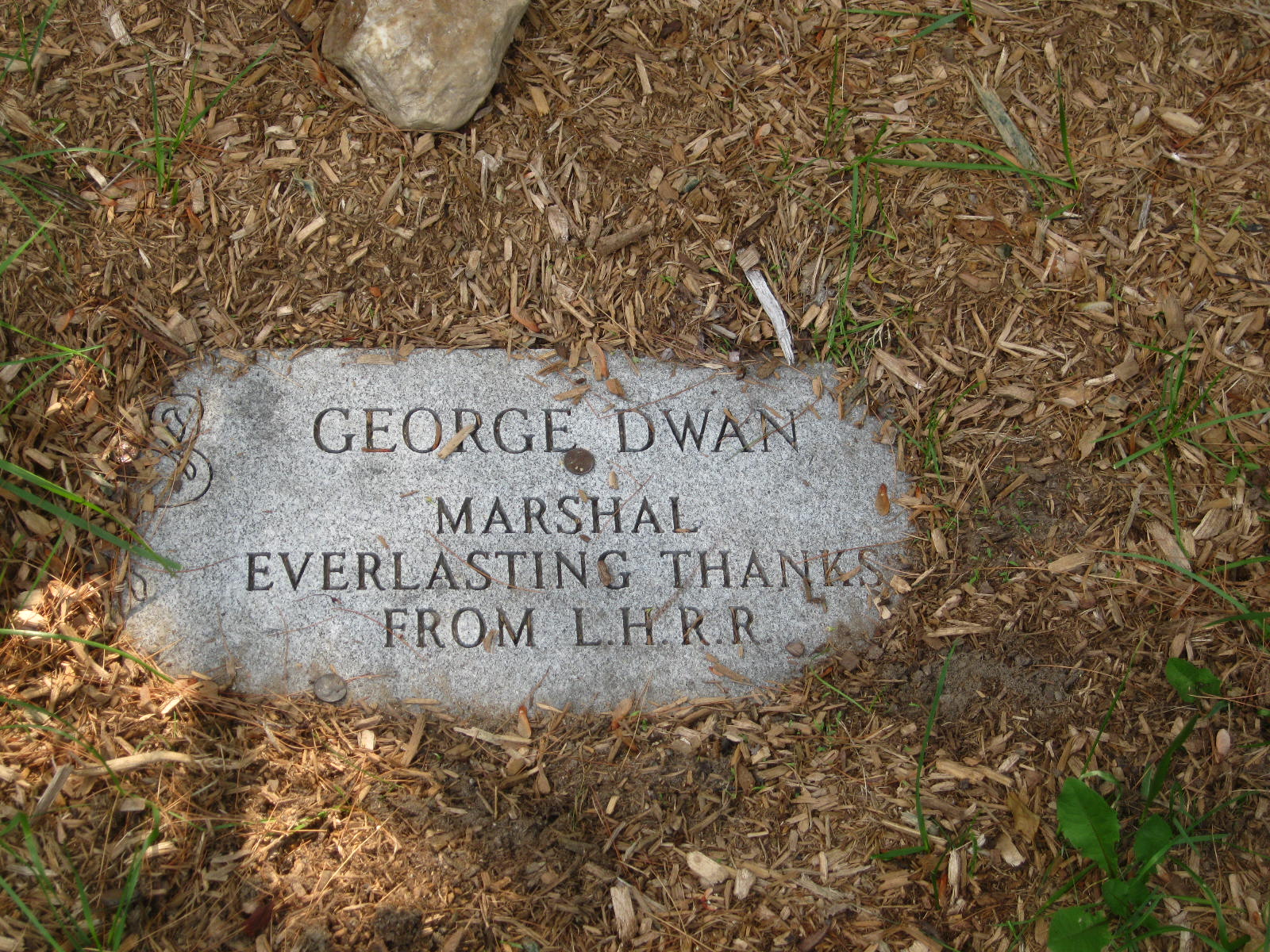
In front of the stone is a marker honoring George Dwan’s service to the Litchfield Hill Road Race.  It is fitting that a flamingo sits in the marker’s upper left hand corner.

Special thanks to Roberta Coffill Healy for sharing her memories of George Dwan and the story of Road Race Park!

West Cemetery’s Civil War Effigy Graves

IMG_3402Memorial Day is an appropriate time to reflect on the staggering statistic that forty percent of all Union dead in the Civil War were unidentified.  While this was a marked improvement from the Mexican War fifteen years earlier – in which 100% of the American dead were buried in unmarked graves – it nonetheless posed a particular problem for Americans.

death-george-washington

The Death of George Washington – a classic representation of the idea of the “good death.”

Death held a central place in the culture of Victorian America.  Society dictated that there was such a thing as a “good death,” in which the deceased expired in his own home, surrounded by loved ones.  To such a religious society, the dying individual was closer to God, and therefore his final words were dutifully recorded as being of great importance.

TimeCivilWar_p139_Embalming_slideshow

A Civil War embalmer

The deaths of hundreds of thousands of Americans in the prime of their lives at great distances from their homes and families was therefore at variance with the notion of the “good death.”  While thousands of dollars were spent on embalming bodies to return them home for burial,  many families were left without even a place to mourn their fallen soldiers.

IMG_3403A solution was the effigy grave, a memorial stone for a victim whose body – because it was unidentifiable or for financial reasons – was unable to be returned home.  The Civil War graves grouped together in Litchfield’s West Cemetery (with a monument of a drum labeled “Mustered Out) are a good representation of these graves.

IMG_3405These men fought on some of the most famous battlefields of the Civil War.

IMG_3406Others suffered through unimaginable horrors in prisoner of war camps.

Perhaps these memorials gave some comfort to the families of these soldiers in the aftermath of the war.  One hundred and fifty years later, the stones continue to remind passersby of these soldiers’ service to our nation.

Hidden in Plain Sight: The Walking Tour!

OLYMPUS DIGITAL CAMERA

The Litchfield Historical Society is sponsoring a walking tour based on this blog on Saturday, May 18th, at 10:00 a.m.  We’ll explore some of the sites previously discussed on these pages and share thoughts about some that will appear in the future.  The tour will focus on sites on the Litchfield Green and nearby South Street.  Visit the historical society’s website – http://www.litchfieldhistoricalsociety.org – for more information and for registration.

Hope to see you on the tour!

Revolutionary War Soldiers’ Tree

Rev war Tree 2

This small marker stands at the southeast corner of the eastern section of the Litchfield Green.

The first Arbor Day was held on April 10, 1872 and became an international event eleven years later when Birdsley Northrup of Kent, Connecticut, introduced the event to Japan.  However, Theodore Roosevelt’s ascendency to the presidency in 1901 and his emphasis on conservation issues sparked a nationwide surge of interest in Arbor Day.

In 1902 the Mary Floyd Tallmadge Chapter of the Daughters of the American Revolution celebrated the first Arbor Day of Roosevelt’s presidency by planting a tree on the Litchfield Green to commemorate the services of the town’s Revolutionary War soldiers.

Revolutionary War Soldiers

In all, 507 men from Litchfield served the Patriot cause between 1775 and 1783.  The first to serve were the men of the company led by David Welch of Milton, who were called up soon after news of Lexington and Concord arrived.  A second company enlisted in January 1776 to serve for the defense of New York City.  They drafted a contract specifying the terms of their service under Major General Charles Lee, stating that they were convinced of “the Necessity of a body of Forces to defend against certain Wicked Purposes formed by the instruments of Ministerial Tyranny.”  They specified, however, that they would not serve for more than eight weeks, and stated that General Lee had “given his Word and Honor” to uphold these terms.

fort washington

The Battle of Fort Washington

In November 1776 another company of Litchfield men under Captain Bezaleel Beebe set off for New York.  Thirty-six handpicked men of the company under Captain Beebe were sent to reinforce the American garrison at Fort Washington (today the Manhattan end of the George Washington Bridge).  The men marched into a trap, and were forced to surrender with the entire 2,600 man garrison of the fort.  Although the men were exchanged about a month later, only 11 of these men made it home to Litchfield.

In March 1777 a new call for troops went out, and Litchfield was tasked with enlisting 92 of its men.  The town voted to pay 12 pounds per year to each soldier and to supply “necessaries” to each soldier’s family.  A final call for troops reached town in 1781, and a “selective draft” took place, in which the town was divided into three classes and each class was expected to raise a certain number of men.

Interior of the Old Jersey Prison Ship

Interior of a British prison ship

In addition to those men who were killed and wounded in battle, twenty Litchfield men died while on the dreaded British prison ships.

Rev War Tree

Today, a small stone marker stands at the foot of the tree dedicated to these soldiers.  Its faded inscription reads:

Planted in Memory of

Litchfield’s Revolutionary Soldiers

by the

Mary Floyd Tallmadge Chapter

DAR

Arbor Day 1902

Litchfield’s National Historic Landmark Marker

Litch His D 3

On the southeast corner of the middle section of the Litchfield Green stands a stone marker with an engraved bronze plaque.  It reads:

Litchfield Historic District

Has been designated a

Registered National

Historic Landmark

Under the provisions of the

Historic Sites Act of August 21, 1935

This site possesses exceptional value

In commemorating or illustrating

The history of the United States

United States Department of the Interior

National Park Servce

1968

The United States government maintains a National Register of Historic Places identifying structures or locales significant in our nation’s history.  There are more than 85,000 places on this list.  Of those, only 2,430 have been designated as National Historical Landmarks.  These sites have been so recognized because they have been identified as possessing national-level historic significance.  Applications for such designation must meet one of six criteria:

·  Sites where events of national historical significance occurred;

·  Places where prominent persons lived or worked;

·  Icons of ideals that shaped the nation;

·  Outstanding examples of design or construction;

·  Places characterizing a way of life; or

·  Archeological sites able to yield information.

Litch His D 1

In the application for designation as a National Historic Landmark in 1967, Charles W. Snell wrote that “Litchfield is probably New England’s finest surviving example of a typical late 18th century New England town.”  He especially tied the district’s significance to the fifteen frame houses from the late 1700s and the three from the period 1800-1828 that still stood in the center of town.

OLYMPUS DIGITAL CAMERA

Snell further established that several of these houses were designed by William Sprat, a British architect turned soldier who was captured at Saratoga and who, as a prisoner of war, was brought to Connecticut.  He remained in the state after the war, renewing his architectural career.  Sprat was well known for his Late Georgian style, typified in Litchfield by the Julius Deming house and the Sheldon Tavern.

LHD_Litchfield_Borough_Map_TownWebsite

The Litchfield Historic District is defined by the National Park Service as including the east and west sides of North and South Streets to the rear property line, running from Prospect Street on the north to Gallows Lane on the south.  It also includes the building fronting the northeast side of the green, those structures from the Congregational Church to North Street.  In total, the district comprises about 20 acres.

north street 1906

North Street 1906

Architectural features were not the only feature of the town that impressed the National Park Service, who in their designation noted “the great elms which now form a broad and beautiful archway over North and South street.”  Thanks in part to this designation, 21st century residents and visitors see parts of Litchfield through in much the same way as those who lived here two hundred years ago.

The Windmill Hill Windmill

Cistern and Windmill

We take to the woods for many reasons.  Thoreau famously wrote, “I went to the woods because I wished to live deliberately, to front only the essential facts of life, and see if I could not learn what it had to teach, and not, when I came to die, discover that I had not lived.”  Most of us take to the woods for less philosophical reasons – to hike, run, snowshoe, mountain bike, or bird watch.  Hidden amongst the Litchfield woods, however, are reminders of the way the land was used in the past.

There is little old growth forest left in Litchfield County.  In the southern environs of the county the land was cleared for farms.  In its northern reaches, Litchfield County’s woods were utilized for the charcoal needed to power iron furnaces.  When these industries began to transform or fade away, the forests reclaimed their original territory, engulfing many man-made objects and alterations to the landscape.

Perhaps this is most true of the White Memorial Foundation, which owns approximately 5,000 acres in Litchfield and Morris.  In these woods remain many implements of the county’s agricultural and industrial past.

bw windmill

The windmill and cistern on Windmill Hill, White Memorial. From Rachel Carley, Litchfield, pg. 212.

One fascinating example is the base on which the White family’s windmill once stood.  The explorer can find it on the appropriately named Windmill Hill, very near the White Memorial visitor center and museum.  The proximity is no coincidence.

John Jay White, whose children established the foundation in the early 1900s, was a New York real estate magnate who moved from 5th Avenue to Litchfield in 1863.  The home he built, Whitehall, in many ways epitomized the Victorian architectural fashion popular at the time.

View of Whitehall

The view toward Whitehall from the site of the windmill.

On the top of a nearby hill White had a cistern built.  A nearby windmill pumped water into the covered cistern.  Pipes then brought the water more than a quarter mile to the house, which thus enjoyed natural water pressure.

windmill

This structure stands on the approximate site of the windmill.

Today, a concrete slab marks the site of the cistern.  A concrete structure stands nearby; it was built to house the electric pump that replaced the windmill but was rendered obsolete a number of years ago when a new well was dug.

carriage house

White Memorial’s carriage house.

Whitehall still stands, albeit in modified form, as the visitor center and museum of the White Memorial Foundation.  Its top floor was removed and modifications made that erased the structure’s Victorian elements.  Only in the carriage house are glimpses of the Victorian splendor that once marked the estate evident.

The Intersection of North and South Streets

A common theme of this blog has been that we can learn a lot more about our historical landscape by getting out of our cars and taking the time to explore our surroundings.  Some things, however, are eminently clear even from behind the wheel of a car.  Most of those reading this post have sat at the red light at the intersection of routes 63 and 202, looking to proceed from North Street to South Street.  It is clear to all motorists that to do so requires a left turn on to West Street, then a right turn on to South Street.  Why are North and South Street not aligned?

An 1814 map of Litchfield, showing the alignment of North and South Streets. From Rachel Carley, Litchfield: The Making of a New England Town

North and South Streets are among the oldest streets in town, and historian Rachel Carley reports that landscaping of these streets began as early as 1771.  An 1814 map records these streets as being “very wide”, while another source states that the streets resembled “long pastures.”  At town meetings in 1771 and 1785, it was decided to straighten North and South Streets.

Nathaniel Hawthorne

Nathaniel Hawthorne visited Litchfield in 1838, and marveled at the width of the streets, and the islands of grass that divided the thoroughfares.  He wrote that “nothing can be neater than the churches and houses” along the two streets.

An alder swamp

This was, however, not always the case.  Alain White, in his history of Litchfield, states that the likely reason for the wide streets was “more for the convenience of the cattle than the delight of residents and strangers.”  White further reports that the awkward alignment of North and South Streets may have been due to an alder swamp along the west side of South Street, which forced that street to be moved a few yards to the east.    However, White also recounts that the zig-zag of the two streets might have been due to the presence of a stately oak, “so beautiful that the settlers laid out North Street … to the west to avoid having to cut it.”  There is a third possibility.  The paths of the two streets follows the crest of the ridge on which they were built.  This was likely the route of the earliest footpaths in town, and it simply may have been more convenient to blaze the roads along the same lines.

There is one other interesting note about the layout of North and South Streets.  It was common in colonial New England town to lay out the streets on the lines of the cardinal directions.  Litchfield is unique only in that those streets – North, South, East, West – have retained their directional names.  However, North Street is not aligned to 0 degrees, but rather to 13 degrees.  This is a result both of the original layout of the street – it was, for whatever reason, not aligned to true north – as well as the fact that magnetic north has moved approximately five degrees to the northeast since they town was laid out in the early 1700s.

Some thoughts on Litchfield’s clocks

While driving along West Street in Litchfield one may catch a glimpse of the time from the clock of the Congregational Church, or in the tower of the Litchfield County Court House.  Subconsciously, the driver is forced to think back to his or her student days to convert the Roman numerals on the face of the clock to Arabic numerals.  This is all done very quickly, and without much thought.

Out on foot to explore his surroundings, however, one may recognize that the faces of these two clocks do not properly correspond to traditional Roman numerals.  Instead of using “IV” for four o’clock, both of these clocks use “IIII.”

London’s Big Ben

They are not alone.  It is customary for clockmakers to substitute “IIII” for “IV” on their works.  There are notable exceptions – Big Ben, the famed London clock whose tower was renamed for Elizabeth II this year in honor of her diamond jubilee, sports the numeral “IV.”  As with so many traditions, there are conjectures as to their origin, but no definitive explanations.

Some speculate that the use of “IIII” provides symmetry to the clock face.  One through four o’clock, only make use of the numeral “I” while the next four hours utilize “V” and “I” and the final four use “X” and “I”.

Does this clock face demonstrate a lack of balance or symmetry?

Others say that the explanation is that the numeral “IIII” provides a better balance to its counterpart “VIII” than “IV” would.  Don’t tell Big Ben.

Jupiter (IVPITER), also known as Jove (IOVI)

Still others hold that the tradition dates back to the Romans, who never used “IV” on their clocks because the letters “IV” were the first two letters of their spelling of the god Jupiter (IVPITER), and they didn’t wish to tempt fate.  This explanation would make for a good story if the Romans actually used clocks.  Does the numeral “IV” appear on sundials?

Those pessimistic about the nature of mankind argue that it is easier to count by adding I’s than it is to subtract I from V, an argument that does not take into account that 9 is “IX” and not VIIII.

The Wells Cathedral Clock

As this blog celebrates history, let’s accept that the tradition follows the lead of the oldest extant public clock, the Wells Cathedral Clock.  This clock, found in the west of England, proudly displays four o’clock as “IIII”, and has since its installation, which was – at the latest – in 1392.

The present Litchfield Congregational Church was built in 1829; however, when a new church was built in 1873, the structure was used for a variety of purposes, including as a movie theater and roller skating rink.  It was restored to its original use in 1930, as part of the town’s Colonial Revival makeover.  The clock would have served important purposes, not only calling residents to worship, but also pealing to announce important news or of fire.

The Litchfield County Court House boasts a Seth Thomas clock tower.  This was installed in 1890 as part of the rebuilding of the court house following an 1886 fire.  When the court house was remodeled in 1913-14 – again, to make the structure fit with its Colonial Revival surroundings – the clock tower was retained.

These two clocks don’t display the exact same time, and as such are vestiges of a bygone era, when passersby didn’t need a digital device connected to satellites to provide them with the precise time.  Most still relied upon sundials and hour glasses to tell time; perhaps in a rapidly changing world, the numeral “IIII” grounded them in ancient traditions.

Gallows Lane and the Execution of Barnett Davenport

Street names are often guides to a town’s past.  In Litchfield’s case, this is perhaps most graphically illustrated with Gallows Lane.

Most town residents have heard the story that the street got its name because executions once took place there.  The historian – trained to be a skeptic – questions this piece of lore.

But it’s true.  And the story reveals crimes of a bloody nature we don’t often associate with our forefathers.

Barnett Davenport was born in the Merryall section of New Milford in 1760.  At 16 he joined the Continental Army to fight in the American Revolution.  He served under George Washington, and was at Valley Forge, Fort Ticonderoga, and Monmouth Court House.  He had always been a troubled youth and was a convicted horse thief.  Perhaps because of his demons, or because he had simply had enough of war, Davenport deserted and returned home.

Early American grist mill

He took a job with Caleb Mallory, a farmer who operated a grist mill along what is now Route 109 in Washington.  Mallory and his wife Jane had two daughters who lived in the area.  One of the daughters had three children – a daughter Charlotte, 9, and sons John and Sherman, 6 and 4.  In February 1780, Davenport convinced Caleb’s two daughters to go on a trip.  With the two away from the house, Davenport entered the home on the night of February 3rd, and beat Caleb, Jane and Charlotte to death.  Looting the house of its valuables, he set it ablaze as he left, killing John and Sherman.

Reverend Judah Champion

Davenport escaped on foot and hid out in a cave in Cornwall for six days.  Captured, he was brought to Litchfield where he was arraigned and gave a full confession, likely to Reverend Judah Champion of Litchfield’s Congregational Church.  The confession remains in the archives at the University of Virginia.

Roger Sherman

He was put on trial, which was presided over by Roger Sherman, who previously had served on the committee that wrote the Declaration of Independence.  Sherman sentenced Davenport to forty lashes and then to be hanged.  The execution took place at Gallows Hill on May 8, 1780.  In 1768, a Native American named John Jacob had been hanged there for the murder of another American Indian.  In 1785, Thomas Goss of Barkhamsted was also hanged on the hill, for the murder of his wife.

Davenport would likely have been led in a procession from the Litchfield jail to the site of the gallows.  It was quite common in early America for large crowds to turn out for an execution, as it was considered an opportunity for moral instruction for children.  The sheriff would read the sentence to the condemned, who would be hooded and mounted on the stand.  A minister would give a sermon.  With the noose placed around Davenport’s head, the trap door was sprung.  The body would be left hanging for some time, a reminder to passersby of the dangers of immorality.

Gallows Hill, frightening now only to Litchfield runners, was once a site terrifying to the condemned.

Gallows Lane was once called Middle Street and at 28 rods (154 feet) was the widest in Litchfield.  Like many other streets, its name speaks to a dramatic past.

For more information on Barnett Davenport, see a Danbury News-Times article on the excellent work of a New Milford historian:  http://www.newstimes.com/local/article/New-Milford-historian-unearths-account-of-984284.php

West Street – Then and Now

Return visitors will recognize the above image as the banner used on this blog.  It depicts Litchfield’s West Street, likely at some point in the late 1920s or early 1930s.  Shot in black and white, it was later colorized for use on a post card.

Here is the same view on sunny fall morning in 2012:

A later post will explore the history of Litchfield’s Historic District.  But the juxtaposition of these two images is testimony to the remarkable job of preservation done in the center of town.  The most striking difference is that the street has been paved; also, it appears that West Street once featured parallel parking.  The right side of the building on the extreme right of the image is now red instead of gray.  The stores in the center of the 2012 view have painted their fronts white, which accentuates the colonnade.  Note that the signs on the building have changed over time.  In the top image, one business has a marquee-style sign, with the other businesses have prominent signage above their store fronts.  Today’s stores have less prominent signs.

Otherwise, the appearance of the street is virtually identical.  The notable architectural features – the bricks in the shapes of diamonds, peaks along the roofs, the patterns along the tops of the facades – all remain.

The historic district was created to protect the town’s colonial character.  Along West Street, however, it has been remarkably successful in preserving the character of the early 20th century.