White Memorial: Japanese Tea House

img_7720

Remains of the Whites’ Japanese tea house

Many of the trails that wind through the White Memorial Conservation Center were originally constructed as carriage roads for Alain and May White. Great care was taken in building this network of roads, as evidenced by the many extant bridges, culverts, and drainage ditches. Carriage rides on roads carved out of forests was a popular leisure activity for wealthy Americans in the late 19th and early 20th century. The Rockefellers, for example, built 45 miles of carriage roads at Kykuit, their Tarrytown, New York, estate, eighteen miles or roads at their Forest Hill, Ohio, estate, and 57 miles in what is now Acadia National Park in Maine.

img_7718

Beaver Pond overlook, White Memorial Foundation

Alain White oversaw the construction of dozens of miles of roads at Whitehall, what is now White Memorial. From the 1870 carriage house, the Whites would drive their team of horses around their property. Approximately four miles from their home was Beaver Pond. High above the pond they constructed a pull off so that they could admire the vista from their carriage. And on the shore of the pond, White built a Japanese tea house. Here Alain and May could entertain friends before returning back home.

Image result for frederick church

Frederic Church, Twilight in the Wilderness, 1860

Wealthy Americans of this period were captivated by paintings by the likes of Frederic Church and Winslow Homer of the American wilderness and looked to have their own experiences in nature. And if that could be done by constructing a Japanese tea house on ground seemingly untouched by human hands, so much the better. At about the same time, Robert Pruyn, an Albany banker and businessman, constructed an entire estate with a Japanese theme on nearly 100,000 of Adirondack wilderness in Newcomb, New York. If on a smaller scale, Alain and May White were inspired by similar ideas in Litchfield and Morris.

Advertisement

Wild Garden Monument

garden2

What might appear to be Litchfield’s newest monument is simply an older one, once again back in sight.

In 1922, the White Memorial Foundation leased 150 acres east of Little Pond to the Litchfield Garden Club for the “creation and maintenance of a wild garden containing trees, shrubs and flowers native to Connecticut and to Litchfield County.”  (The Garden Club paid $1.00 to lease the land for ten years.) Trails were opened allowing visitors to access the gardens and Little Pond, and the Sutton Bridge was built to cross the Bantam River.

Wild Garden Map

A 1932 map showing the Litchfield Wild Garden. The Sutton Bridge appears at the bottom. “Map of the Litchfield Wild Garden” Litchfield Historical Society, Helga J. Ingraham Memorial Library. Thanks to Linda Hocking at the Litchfield Historical Society for providing the digital image.

One trail began at the intersection of Old South Road and Gallows Lane, and there the Garden Club placed a monument to greet visitors. It read:

The kiss of the sun for pardon,                                                                                                     The song of the birds for mirth,                                                                                                           One is nearer God’s Heart in a garden                                                                                       Than anywhere else on earth.

The lines are from the poem “God’s Garden” by English poet Dorothy Frances Gurney (1858-1932), and are commonly found on plaques in gardens.

garden1

In 1975, the Wild Gardens reverted back to White Memorial, and the small plot of trees at the intersection of Old South and Gallows soon engulfed the monument. Recently, however, it has been been brought back into view, and while several words are missing from the poem, it remains a tribute to the splendor of the natural world that surrounds Litchfield.

LHRR Series: The Fourth Mile, into White Memorial


gates

The  gates to Whitehall, the estate of Alain and May White. The four mile mark of the Litchfield Hills Road Race is just beyond these gates.

Passing the third mile marker, runners enter into the forests of the White Memorial Foundation. This was the brainchild of Alain and May White, siblings and children of John Jay White, a New York real estate tycoon who relocated his family to Litchfield following the New York City Draft Riots in the Civil War. The next post in this series will focus on the Whites and their home. As runners enjoy the solitude of the woods along Bissell and Whitehall Roads, let’s focus on their philanthropic endeavors.

An early 20th century view of a scene across from the current White Memorial Visitor Center.

Together Alain and May preserved nearly 9,000 acres of land that today comprise the White Memorial Foundation, Mohawk State Forest and Mohawk Mountain State Park, Kent Falls State Park, Macedonia Brook State Park, the People’s State Forest, Campbell Falls State Park, and portions of the Steep Rock Preserve.

White family holdings along Bantam Lake


It began simply when Alain was fishing in the Bantam River with his friend William Mitchell Van Winkle in 1908. White commented, “Wouldn’t it be wonderful to preserve this river, lake and countryside as we see it now?” With May, he would devote nearly the next half century to acquiring additional lands for a preserve dedicated to the memory of their parents. The Whites’ goal was not simply to allow nature to run its course on these lands. Rather, as historian Rachel Carley notes, they hoped to “make shoreline available for youth camps, simple vacation home and convalescent retreats” This, then, was practical conservationism.

A LHRR runner in the White Memorial section of the race. (Courtesy scottlivingston.wordpress.com)

Runners rightly best remember them today for their remarkable contribution of a 4,000-acre backyard for Litchfield, a refuge not only for runners and animals but for hikers, bikers, birders, and kayakers.

For more information on the history of the Litchfield Road Race, see Lou Pellegrino’s forthcoming book A History of the Litchfield Hills Road Race: In Smallness there is Beauty. (Available May 2016)

Land Conservation in Litchfield County

There were more trees in Connecticut in 2010 than there were at any time since 1850. This, of course, reflects different land use patterns that have emerged as the state’s economy has evolved. In Litchfield County this is also a result of the willingness of residents to conserve rather than develop their land.

Roxbury

The Orzech Family Preserve, 112 acres near Route 67 and the Shepaug River in Roxbury.

The celebrities and artists who have long been attracted to the area have also been prominent supporters of land conservation, and nearly every town in the county has a land trust.  Some of these trusts are extraordinarily active; the Weantinoge Heritage Land Trust, for example, has preserved over 4,000 acres of land, mostly in Litchfield County.  The results of this movement have been profound. Perhaps the best example comes from George Black’s book, The Trout Pool Paradox, in which he laments the Naugatuck River south of Torrington as a “chemical sewer,” while the Shepaug River is the “Platonic ideal of a trout stream.”

IMG_2920

This carving on a boulder in the White Memorial Foundation honors Alain and May White.

Alain and May White were among the most extraordinary conservationists in the county. In addition to their own 4,000 acre preserve (what is now the White Memorial Foundation), the siblings additionally donated nearly 6,000 acres to fourteen Connecticut state parks, mostly in Litchfield County.

marcicostas

The Macricostas Preserve of Steep Rock, along Route 202 in Washington.

A similar operation to the Whites was taking place in Washington, where noted architect Ehrick Kensett Rossiter made the Steep Rock Land Trust his most lasting legacy to the town.  Rossiter began with a 100-acre purchase in 1881 – what would become the heart of the preserve – and continued to add land to the trust he established. Additional donations from the Van Sinderen and Macricostas families have brought Steep Rock’s holdings to nearly 3,000 acres.


Daffodils

The Morosani Preserve in Northfield.

The examples of the Whites and Rossiter are matched in spirit if not in size by dozens of more conservationists who have helped to preserve the county’s landscape.  Among these are the Morosanis, whose Laurel Ridge Foundation is noted for its daffodils every spring, Edith Morton Chase, daughter of a brass magnate whose home became Topsmead State Forest, and S. Dillon and Mary Livingstone Ripley, whose Kilvarock estate became the Livingstone Ripley Waterfowl Conservancy.


Stone Walls

DSC_1017

With the leaves off the trees fall is a great time to explore the stone walls of White Memorial. There is, perhaps, no better-known example of man’s reshaping of the Litchfield County landscape than stone walls. Robert Thorson, author of the superb history of these creations, Stone by Stone, wrote that “abandoned stone walls are the signatures of rural New England, the “relics of a vanished agricultural civilization.”

Perhaps there is no better metaphor for the history of Litchfield County than its ubiquitous stone walls. Constructed from colonial times through the middle of the nineteenth century, they stand as testimony to the intrepid early settlers who cleared the land in the hopes of making a living from the county’s soil. In plowing their fields, they utilized these unwanted stones to dam streams, mark roadways and property boundaries and pen in livestock. Yet the explorer is struck to find these vestiges of an earlier time in the county’s deepest forests, an indication that this land was once cleared and worked but has since been reclaimed by forests as lifeways in the county changed.

DSC_1015

The stones that form these walls were deposited by the Laurentide Ice Shield 15,000 to 30,000 years ago, which scraped down to New England’s bedrock and scattered billions of stones across the region. Initially, the earliest stonewalls were built from stones obtained from quarries. The “Little Ice Age” of the 18th century, however worked stones to the surface through deep freezes and the erosion caused by spring runoffs. Thus, the clearing of stones from pastures and fields became an annual spring ritual. Farmers brought these stones to the fences that lined their properties, often by hand or by sleds pulled by oxen. Over time, these piles were reworked into more architecturally-significant structures as the supply of labor on farms grew.  Eventually the walls shaped the landscape by forcing rain to different streams or building up soils.

DSC_1033

Stone walls served several purposes for farmers. When the communal land practices of the earliest colonial days shifted to a philosophy of individually owned land, stone walls were used to define boundaries. Farmers often piled stones until they reached the lowest level of a split rail fence.  Stone pens were utilized for what Thorson has termed the “strategic dropping of manure” for use as fertilizer. Elaborate stone walls were utilized as status symbols. More than anything, however, stone walls were simply ways to dump stones that were obstacles to farmers in their fields.

New England farmers built five principal types of stone walls. These are:

DSC_1014

Dumped Wall – A simple line of piled stones.

DSC_1026

Tossed Wall – With stones stacked like firewood, this is the most common of       stone walls. It required a bit more attention that the dumped wall.

DSC_1023

 Single Wall – stones piled on top of each other. These were used to surround pastures.

DSC_1011

Double Wall – Parallel walls with smaller stones used to fill in between.

DSC_1028

Laid Wall – Featured stones in a “weave” pattern.

DSC_1019

A 1939 study estimated that there were 240,000 miles of stone walls in New England, which contained more stone than the remaining monuments of the ancient world put together. Unfortunately, Connecticut (unlike Massachusetts and New Hampshire) has no law that protects its stone walls, and they are slowly falling victim to bulldozers or being quarried for new stonework.

Sandy Beach Memorial

2013-08-06 15.06.02

An earlier post examined the memorial to Alain and May White that stands near the Plunge Pool.  That monument, an inscribed boulder in the woods, was erected in 1980.  An earlier monument to these great conservationists stands at the entrance to Sandy Beach.

2013-08-06 15.06.24

In 1953, the White Memorial Foundation dedicated this monument.  It was designed by James Kip Finch, who served on the Foundation’s board of trustees from 1925 to 1966.

Sandy Beach, c. 1930.  (Courtesy Litchfield Historical Society)

Sandy Beach, c. 1930. (Courtesy Litchfield Historical Society)


Sandy Beach is an appropriate place for such a memorial, as one of the goals of the Whites was to make Bantam Lake’s shoreline available to local residents.  The Whites purchased the land in the 1920s from the Wadhams family, who farmed the area.  By 1929 Sandy Beach sported 30 bathhouses as well as a concession stand and a float in the lake.  Sandy Beach was widely popular from its inception.  It hosted nearly 650 visitors on a single day in 1929, and 30,000 people utilized the beach in 1930.  The beach offered cheap entertainment to a region facing the Great Depression.

Photo courtesy of litchfield.bz

Photo courtesy of litchfield.bz

The Whites established the Sandy Beach commission in 1928, which worked with the  Foundation to manage the site.  In 1976 stewardship of the beach passed to the towns of Litchfield and Morris.  After more than 80 years, however, Sandy Beach continues to serve its original purposes of offering local residents a refuge from the summer heat.

The Bantam Lake Ice House

This observation tower along the Lake (Yellow) Trail at White Memorial sits at the point where ice was taken out of the lake and sent to the ice house.

This observation tower along the Lake (Yellow) Trail at White Memorial sits at the point where ice was taken out of the lake and sent to the ice house.

This post marks a new partnership between Hiddeninplainsightblog.com and Litchfield.bz.  Litchfield.bz will occasionally be providing videos showing some of the sites discussed on this blog.

In the days before refrigerators foods either needed to be preserved (through canning, smoking, or salting) or kept fresh through the use of ice boxes.  Ice boxes were dependent upon a steady supply of fresh ice, no easy proposition in the summer months.  To satisfy the demand for blocks of ice, ice was harvested from New England ponds and lakes in the winter (usually in January and February when temperatures were the coldest).

Forty acres of Bantam Lake had to be harvested to fill the ice house.

Forty acres of Bantam Lake had to be harvested to fill the ice house.

The earliest ice harvests were done in the same manner as harvesting crops, with neighbors and friends pitching in and being compensated with a share of the crop.  Specialty tools, including gang saws, chisels and saw plows, were used to cut the ice into blocks which were then transported to ice houses for keeping.  Ice houses were designed with the floor one foot off the ground to allow for the passage of air under the ice.  They featured double walls, one foot apart and packed with shavings or saw dust for insulation.  The floors of these ice houses were pitched to allow for drainage.

DSC_0276

The former machine shop at the ice house complex.

The largest ice harvesting operation in Connecticut was the Berkshire Ice Company (later part of the Southern New England Ice Company) on Bantam Lake.  Their facility stood near the present Litchfield Town Beach on North Shore Road in Bantam.  Here the foreman’s house and machine shop still stand, and the remains of workers’ dormitories and, most impressively, the 700 foot by 125 foot ice house are visible.

The ice house had fourteen  30-foot high storage sections that each held 4,000 tons of ice for a total of 56,000 tons of ice.  It would take 40 harvested acres of ice to fill the warehouse.  The particular challenge the workers faced was getting the ice into the storage house.  This was especially difficult as the ice was cut into the 300-pound blocks preferred for wholesale purposes.  (Retail ice was cut into 25, 50, or 100 pound blocks).

DSC_0248

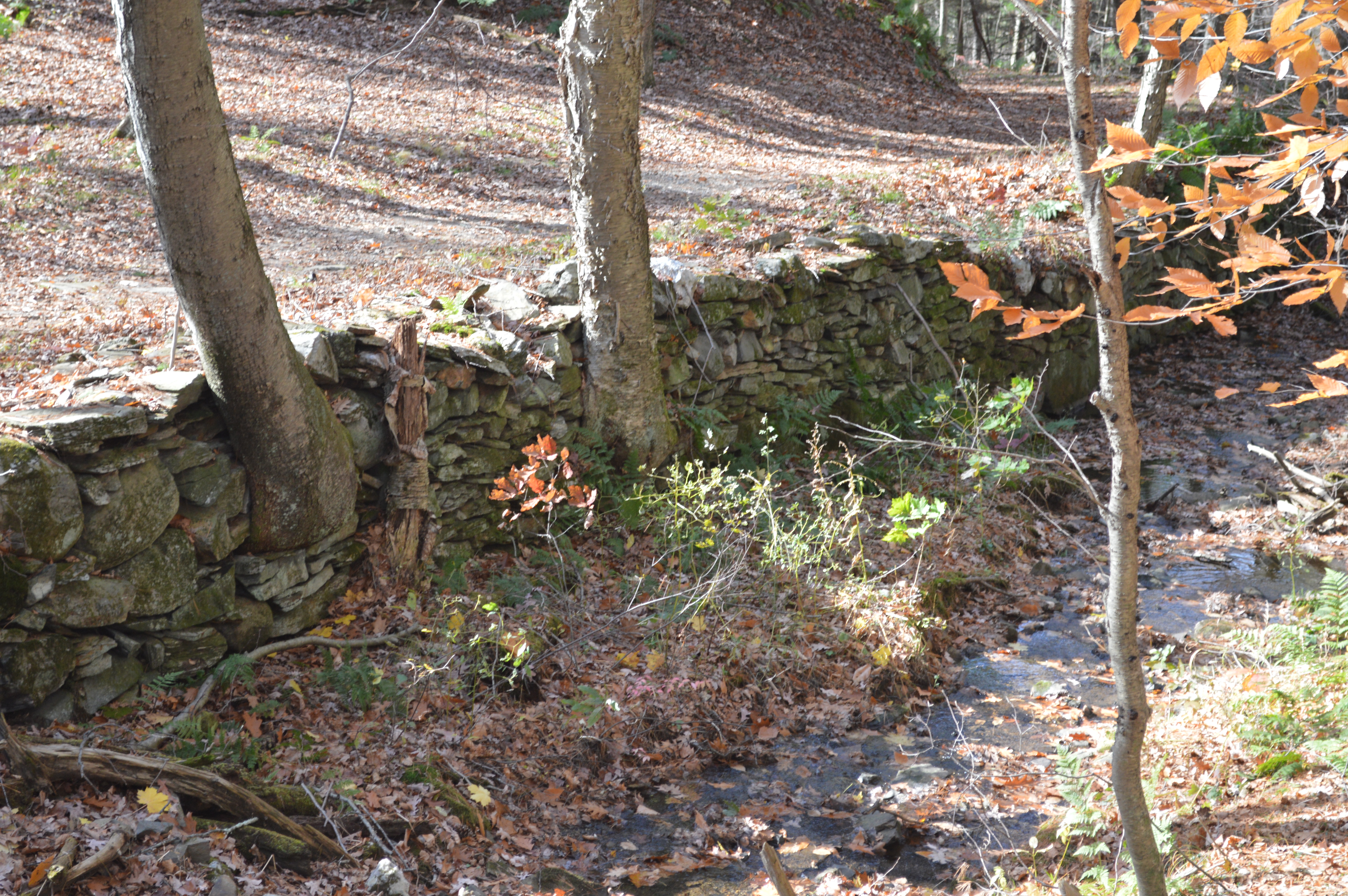
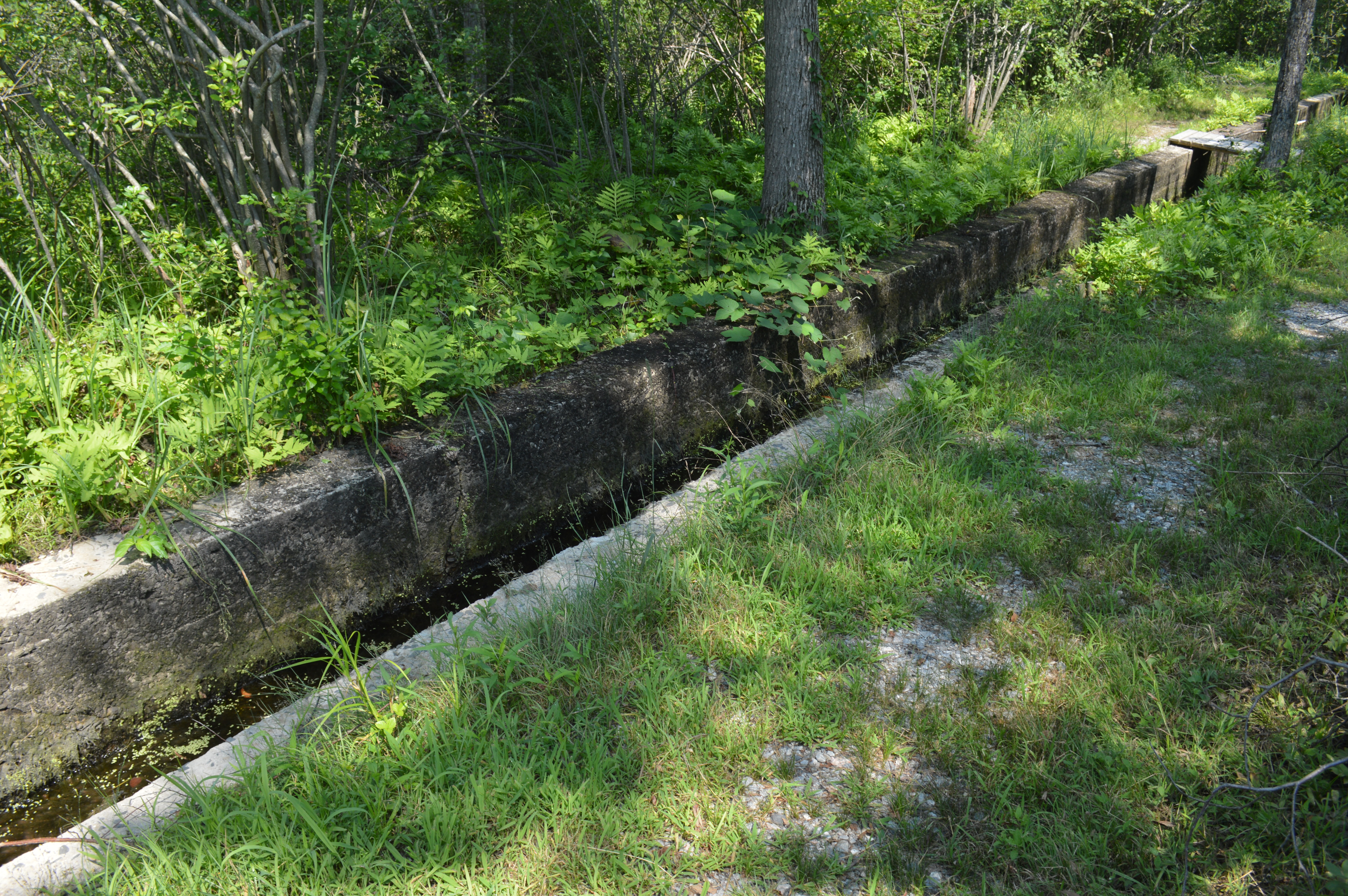
Prior to the conveyor belt system, ice was floated to the ice house via this canal.

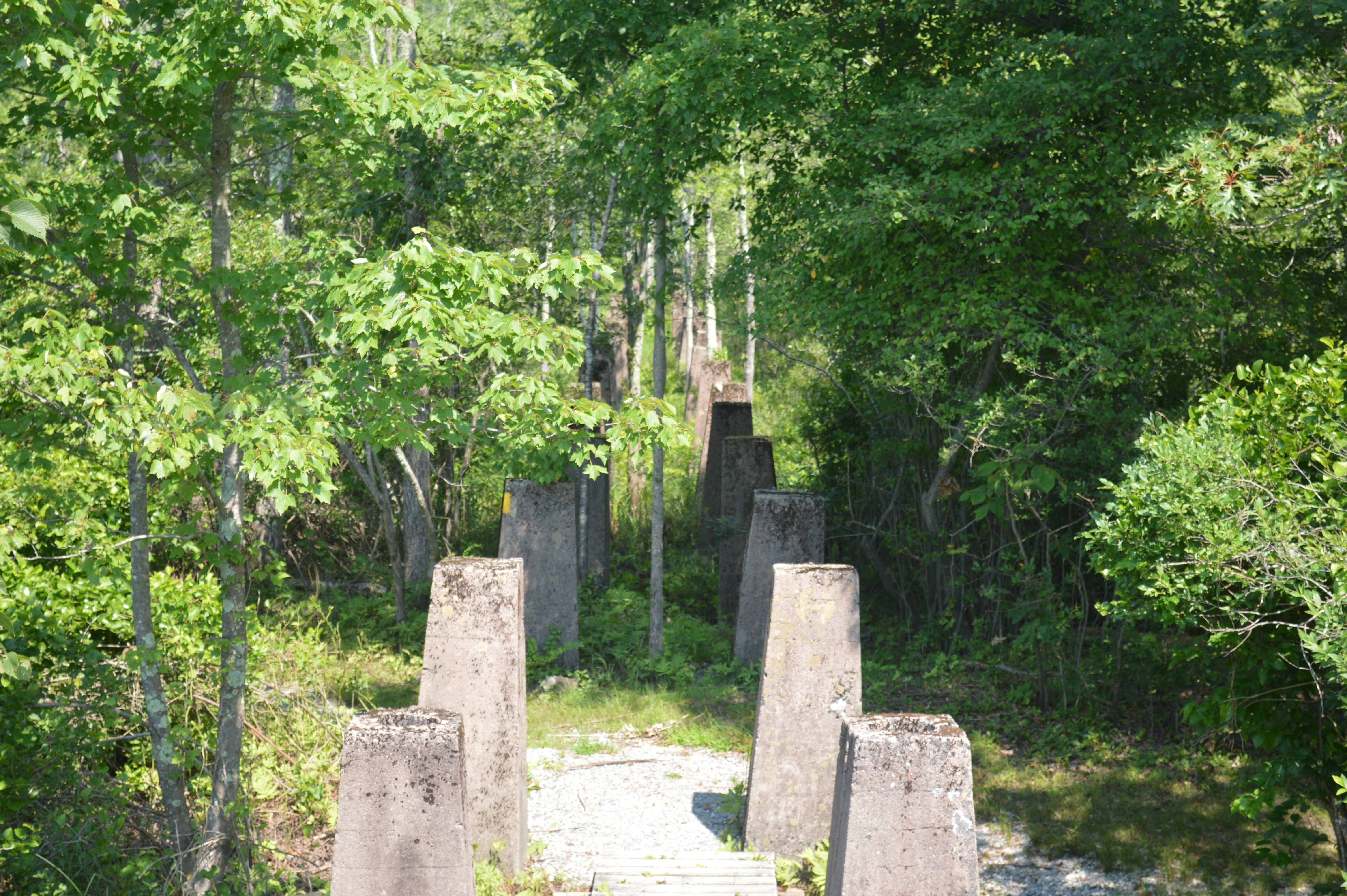
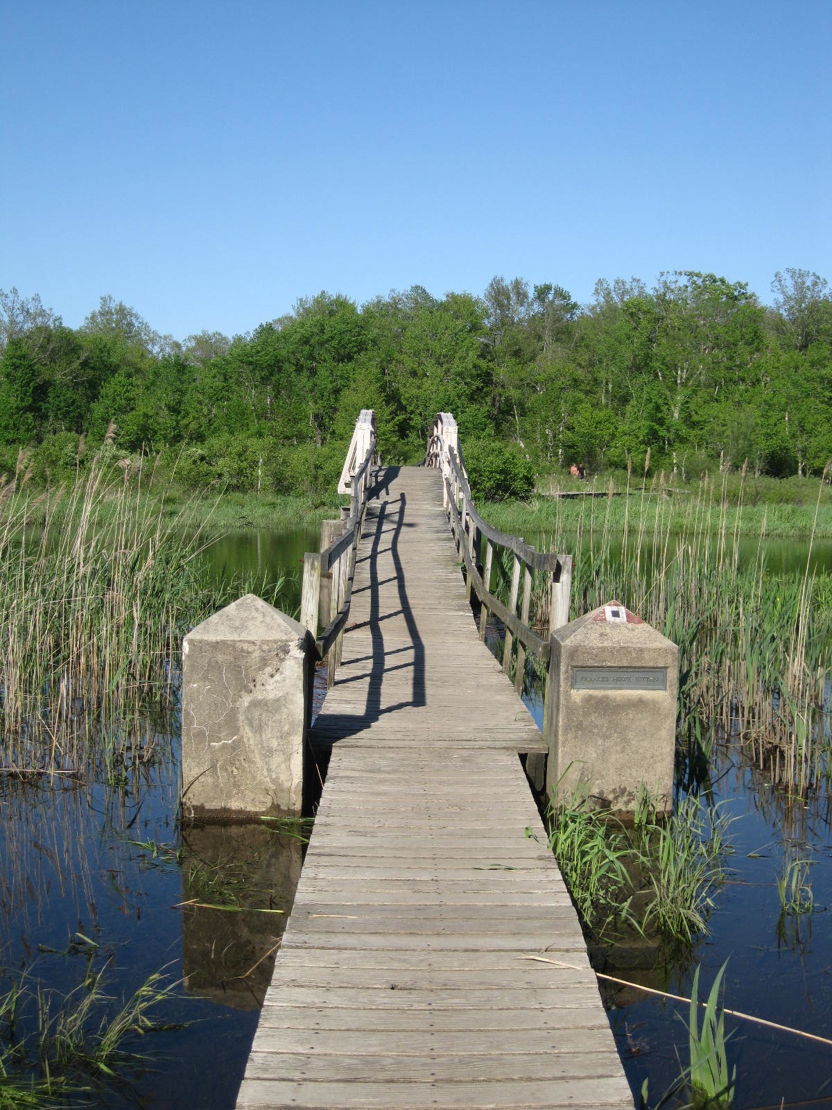
Channels were cut into the lake, and the workers (who were paid 60 cents an hour and worked seven days a week in the mid 1920s) utilized poles to float the ice to a ramp on which rested a conveyor belt.  The concrete pillars of this system still stand as ghostly sentinels in the swampy grounds of White Memorial; the final pillars today support an observation tower on the shores of Bantam Lake.  The conveyor belt was powered by a 100-horse power engine that derived its energy from the Bantam Falls power plant.

DSC_0241

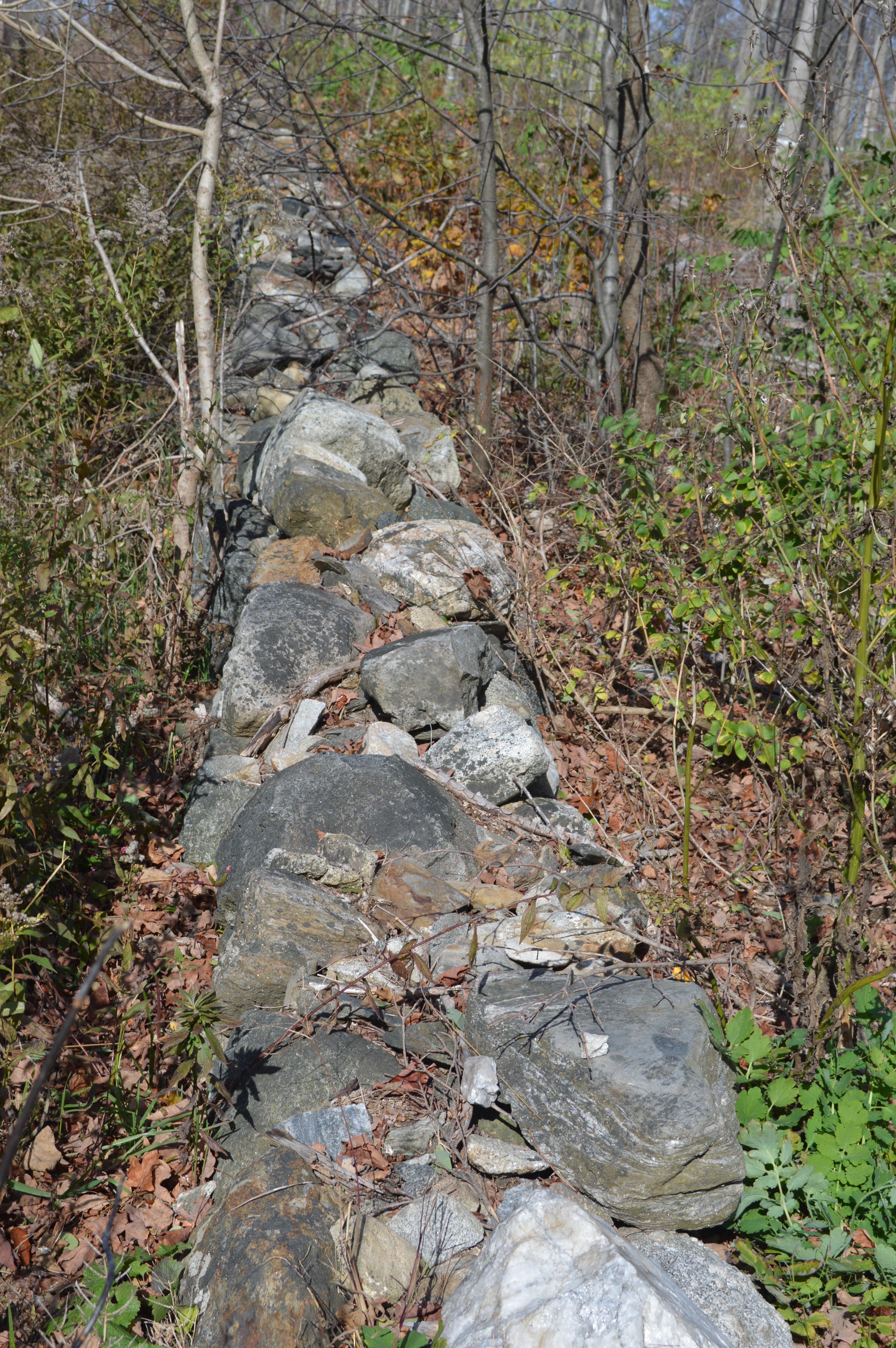
Concrete pillars mark the path of the old conveyor belt.

The conveyor belts ran approximately 1000 feet from the lake to the ice house.  In the summer months, a spur of the Shepaug Valley Railroad ran from the Lake Station (today, the Cove Shops on Route 202) to the ice house, where it split to run parallel so cars could be filled from both sides of the structure.  Up to 20 box cars a day were filled, and the ice was transported as far as Bridgeport.   Alain White, in his History of Litchfield, described the “long trains,” which “pull out daily in the summers, carrying concentrated relief from the Litchfield Hills to the larger cities southward.”

DSC_0278

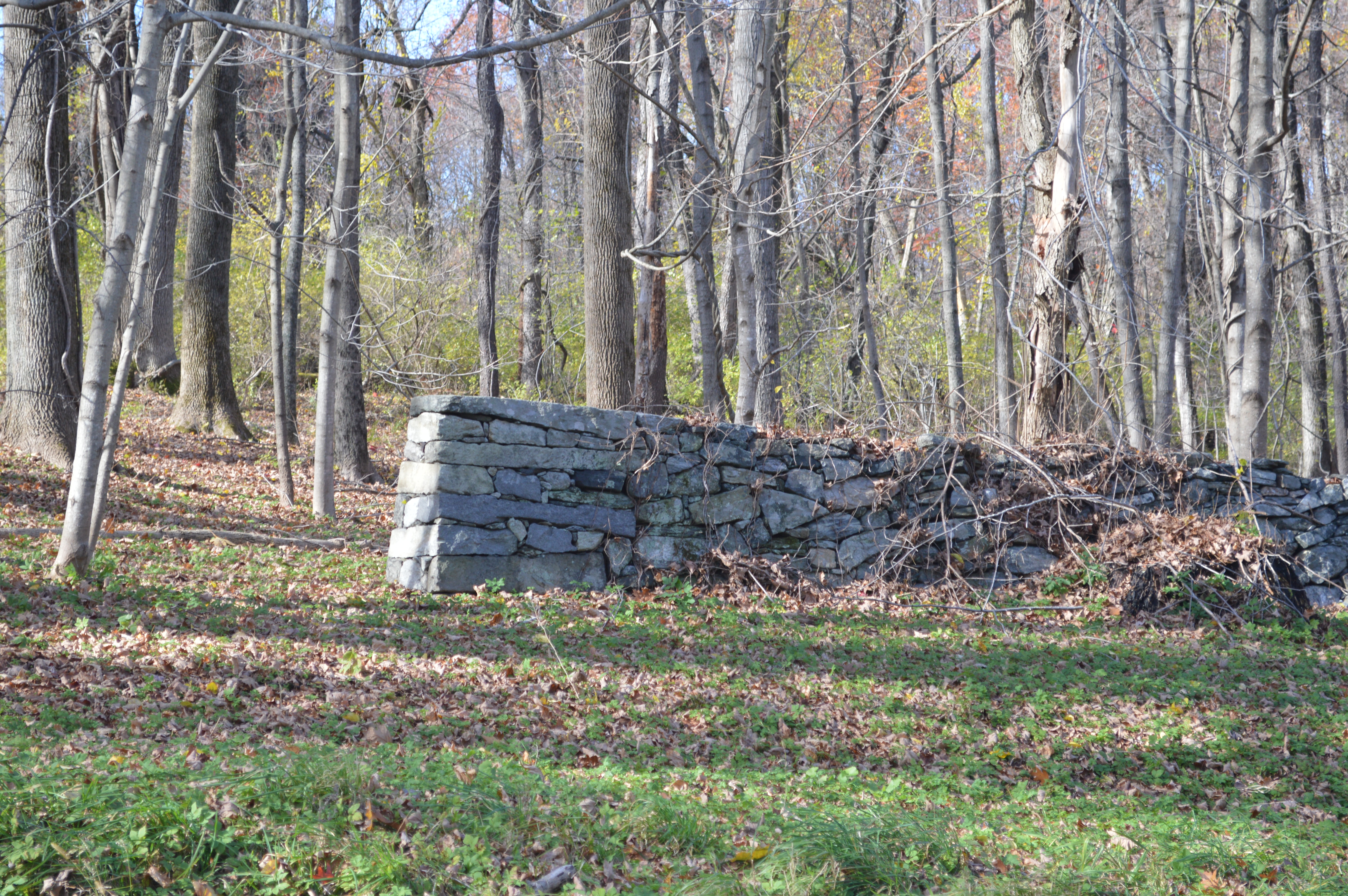
Remains of the ice house foundation, at the southern end of the Butternut Brook trail.

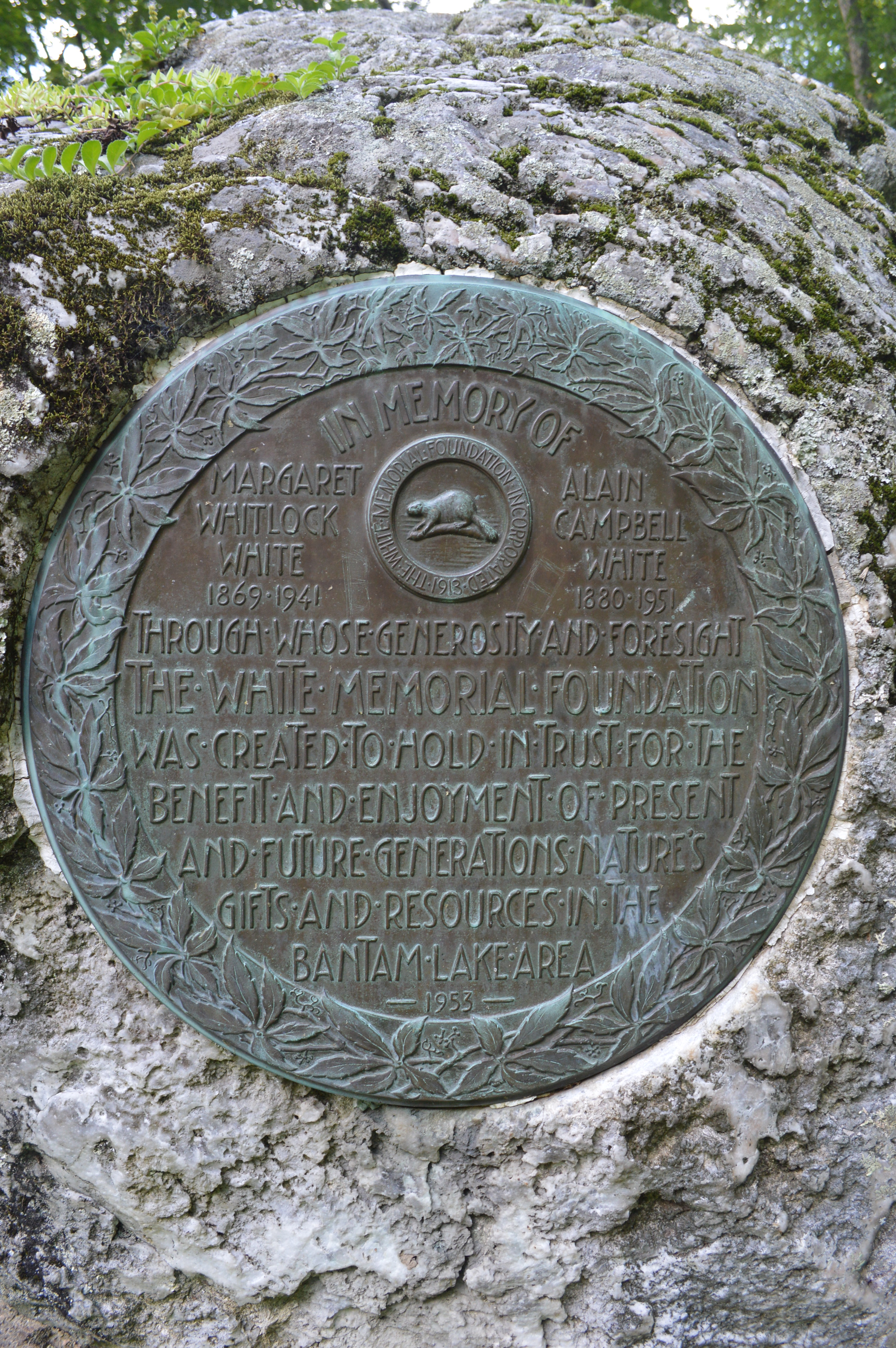
The spread of electricity and refrigerators to households in the 1920s led to a severe decline in the demand for harvested ice.  On August 8th, 1929, a massive fire swept through the facility.  Some have speculated that the fire was caused by spontaneous combustion of either the hay or sawdust at the site, while others reported that their were several cases of arson in the area.  Either way, over $350,000 in damages resulted from the destruction of the ice house building, nine railroad cars, and over 50,000 tons of ice valued at $200,000.  The next year the Southern New England Ice Company sold its land to the White Memorial Foundation; as a result, the foundations remain to remind us of this once vibrant industry.

For the Litchfield.bz video of the Bantam Lake ice house, click here

The Frances Howe Sutton Bridge

sutton bridge

The Frances Howe Sutton bridge on the Little Pond Trail in White Memorial Note the plaque on the right side of the bridge.

The most popular trail in the White Memorial Foundation is the boardwalk that encircles Little Pond.  The bridge in the photograph above, which carries a plaque honoring Frances Howe Sutton, spans the outlet of the pond, where the Bantam River turns toward Bantam Lake.

Wild Garden Map

A 1932 map showing the Litchfield Wild Garden. The Sutton Bridge appears at the bottom. “Map of the Litchfield Wild Garden” Litchfield Historical Society, Helga J. Ingraham Memorial Library. Thanks to Linda Hocking at the Litchfield Historical Society for providing the digital image.

In 1922, the White Memorial Foundation leased 150 acres east of Little Pond to the Litchfield Garden Club for the “creation and maintenance of a wild garden containing trees, shrubs and flowers native to Connecticut and to Litchfield County.”  (The Garden Club paid $1.00 to lease the land for ten years.)  The garden club created trails through this area to allow visitors to access the flora.  This became known as the Litchfield Wild Garden.  In 1928, the Munroe Bridge was built to offer visitors access to the west side of the Bantam River as it flowed into Little Pond.  (This is the bridge near the Litchfield Country Club.)

suttonTen years later, Herbert L. Sutton financed the construction of a second bridge, which was built in memory of his wife, Frances Howe Sutton.  This bridge crossed the river as it flowed out of Little Pond, and gave visitors access to the Pine Island section of White Memorial.

sutton 3In subsequent years management of the Wild Garden passed from the Litchfield Garden Club to the Wild Garden Association and then to the Litchfield Hills Audubon Society.  In 1959, the boardwalk was completed around the entirety of Little Pond, in memory of Ralph T. Wadhams.  Finally, in 1975, the area of the Wild Garden reverted back to White Memorial.  While the trails in this area are no longer maintained, the careful observer can still locate where they once ran.

little pond

The view from the bridge.

In September 1985, flooding from Hurrican Gloria necessitated a rebuilding of the boardwalk.  Ultimately this project required 57,000 board feet of lumber, 2,600 hours of labor, tons of nails, and $73,000 to repair the 1.2 mile trail.  While entire sections of the trail and uncounted individual boards have been replaced since 1985, the structure of the boardwalk remains today.  Those who have ventured to Little Pond for birding in the spring or to admire the stark beauty of a New England winter understand why this trail remains White Memorial’s most popular.

For more information on the Little Pond boardwalk, see Keith R. Cudworth, The White Memorial Foundation:  The First 100 Years, The Legacy of Alain and May White (White Memorial Foundation, 2012).

Road Race Park

Road Race parkWith the 37th annual Litchfield Hill Road Race only days away it seems appropriate to highlight a relatively new monument that shows that commemoration is an ongoing process.  Where the trail over Plumb Hill intersects with Whites’ Woods Road stands Road Race Park, a small plot of land with markers to recognize the contributions of those who have helped make the race possible.

lhrr

Photo courtesy of Waterbury Republican American

What began in 1977 as the brainchild of a few friends to bring to Litchfield a road race modeled after the famed seven-miler in Falmouth, Massachusetts, has grown into a weekend of events that culminates with approximately 1,500 runners making their way through town and White Memorial.  Participants have come from all age groups and dozens of countries and have included those who walk the course to marathon champions Bill Rodgers and Joan Benoit Samuelson.  Runner’s World Magazine declared Gallow’s Hill the eighth most difficult hill in racing.

Of course, none of it would be possible without the volunteers.

flamingoOne of the race’s notable volunteers was George Dwan, who served as race marshal at the site of Road Race park from the first race until his death in 2008.  With his friend Roberta Coffill Healy, Dwan would decorate the area with pink flamingos, silver Christmas trees, pinwheels, and other tacky trinkets.

LHRRWhen George passed away, Roberta continued the tradition with her husband Jack.  She also was instrumental in commemorating the work that Dwan and others put into the race.  On the Saturday before the 2009 race, Road Race Park was dedicated.  It consists of three large stones; those on the left and right are sitting stones.  The center stone is inscribed with the words of race co-founder (with Bill Neller) Joe Concannon, “A labor of love and a celebration of the community.”  On the back of the stone is a running beer mug, a reminder that a sense of fun has always pervaded the race.

DwanIn front of the stone is a marker honoring George Dwan’s service to the Litchfield Hill Road Race.  It is fitting that a flamingo sits in the marker’s upper left hand corner.

Special thanks to Roberta Coffill Healy for sharing her memories of George Dwan and the story of Road Race Park!

The Windmill Hill Windmill

Cistern and Windmill

We take to the woods for many reasons.  Thoreau famously wrote, “I went to the woods because I wished to live deliberately, to front only the essential facts of life, and see if I could not learn what it had to teach, and not, when I came to die, discover that I had not lived.”  Most of us take to the woods for less philosophical reasons – to hike, run, snowshoe, mountain bike, or bird watch.  Hidden amongst the Litchfield woods, however, are reminders of the way the land was used in the past.

There is little old growth forest left in Litchfield County.  In the southern environs of the county the land was cleared for farms.  In its northern reaches, Litchfield County’s woods were utilized for the charcoal needed to power iron furnaces.  When these industries began to transform or fade away, the forests reclaimed their original territory, engulfing many man-made objects and alterations to the landscape.

Perhaps this is most true of the White Memorial Foundation, which owns approximately 5,000 acres in Litchfield and Morris.  In these woods remain many implements of the county’s agricultural and industrial past.

bw windmill

The windmill and cistern on Windmill Hill, White Memorial. From Rachel Carley, Litchfield, pg. 212.

One fascinating example is the base on which the White family’s windmill once stood.  The explorer can find it on the appropriately named Windmill Hill, very near the White Memorial visitor center and museum.  The proximity is no coincidence.

John Jay White, whose children established the foundation in the early 1900s, was a New York real estate magnate who moved from 5th Avenue to Litchfield in 1863.  The home he built, Whitehall, in many ways epitomized the Victorian architectural fashion popular at the time.

View of Whitehall

The view toward Whitehall from the site of the windmill.

On the top of a nearby hill White had a cistern built.  A nearby windmill pumped water into the covered cistern.  Pipes then brought the water more than a quarter mile to the house, which thus enjoyed natural water pressure.

windmill

This structure stands on the approximate site of the windmill.

Today, a concrete slab marks the site of the cistern.  A concrete structure stands nearby; it was built to house the electric pump that replaced the windmill but was rendered obsolete a number of years ago when a new well was dug.

carriage house

White Memorial’s carriage house.

Whitehall still stands, albeit in modified form, as the visitor center and museum of the White Memorial Foundation.  Its top floor was removed and modifications made that erased the structure’s Victorian elements.  Only in the carriage house are glimpses of the Victorian splendor that once marked the estate evident.