LHRR Series: The Last 1/10th Mile

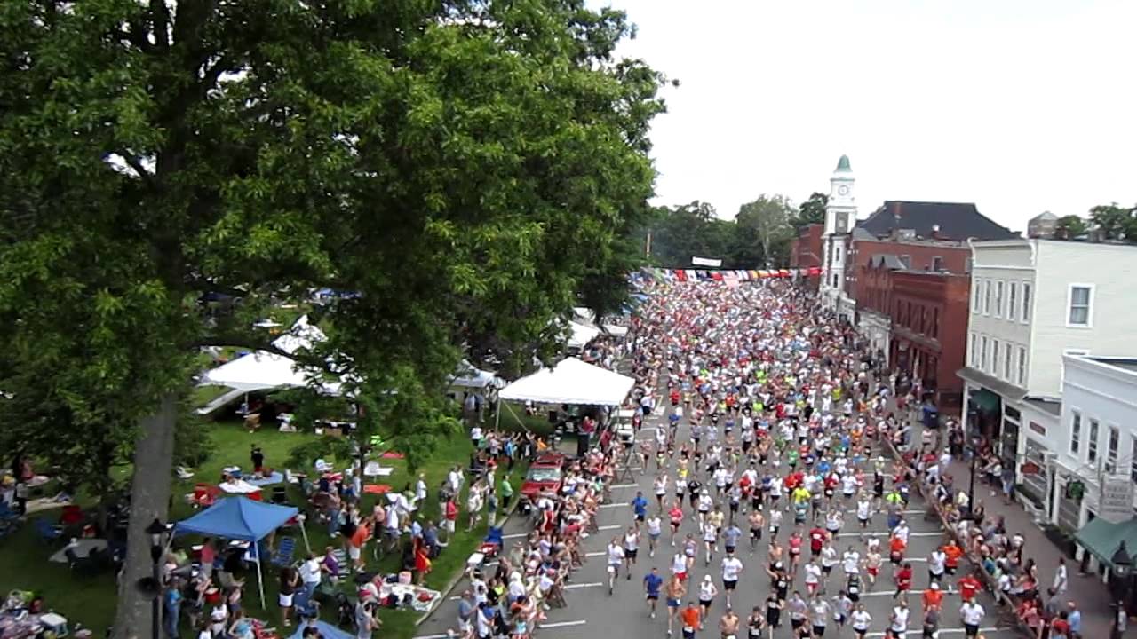
Runners making the final turn from South Street to West Street experience the surge of adrenaline that comes with the wall of sound rising from the crowds along the sidewalk and the Green. The Green, the center of community activity in Litchfield, has not always been the pastoral heart of the town.

An 18th century map of Litchfield drawn by Ezra Stiles. Courtesy of Yale University.

Like many Connecticut communities, the Green began as simply a very wide road. In Litchfield, it was Meeting House Street, and was what is now East and West Streets. The western portion of this road was 264 feet wide, with the eastern portion stretching to 330 feet wide. (Colonial roads were much wider than our modern roads, in part because the lack of effective road building tools meant that large boulders and tree stumps would be left, so travelers needed ample space to get around them.) In the roadbed where Meeting House Street intersected with North and South Streets stood the Congregational Church. In 1752, the county courthouse was also built in the center of the road, and the sheep and pigs of local farms milled about.

Lyman Beecher, minister at the Litchfield Congregational Church from 1810 to 1826.

At that point the town did not have a centralized commercial district, but in the coming decades, especially during the Revolutionary War, businesses in town clustered around this intersection. An 1814 map of town shows a great deal of activity on North Street, with the courthouse having been moved to the southern side of West Street. The Congregational Church – with Lyman Beecher as minister – still stood in the intersection. This is commemorated with a monument that today is in the southern portion of the Green; there was, however, no grass there in 1814.


The Litchfield Green,. 1907.

What we would recognize as the Green began to emerge after a new Congregational Church was built outside of the intersection in 1828-29. The town decided to grade its central area to create a commons. This was divided into three sections, East, West, and Center Parks. By the time of the 1851 county centennial, this had become the major meeting place in town. The early 20th century would see transformations of the Green by Litchfield’s Village Improvement Society, but for the new sidewalks, lighting, and trees that came and went, the Green had become the heart of town, which it will be tomorrow when approximately 1,500 await the start of the 40th Litchfield Hills Road Race.

Good luck to all runners!

For more on the development of the town of Litchfield see Rachel Carley’s book Litchfield: The Making of a New England Town.

For more information on the history of the Litchfield Hills Road Race, see Lou Pellegrino’s book A History of the Litchfield Hills Road Race: In Smallness there is Beauty (now available at the Litchfield Historical Society).


LHRR Series: The Seventh Mile: Gallows Hill

A lone runner practicing on Gallows Lane. Courtesy of the Hartford Courant.

A seventh mile featuring Gallows Hill is certainly an ominous way to end a road race, and the historian, trained to be a skeptic, wonders if the appellation survives a historical inquiry. It does, as Gallows Hill was the scene of three of the four widely documented executions in Litchfield.

The pillory, a frequently used method of punishment in early America.


There are many instances in Litchfield history of the gallows being used for punishment that did not quite rise to the level of execution. For example, Sheriff Lynde Lorde wrote  in February 1776, “I caused the within named John Thomas to be taken from the common Gaol in Litchfield to the place of Execution and there Set upon a Gallos with a Rope Round his Neck for the full Term of one hour and Then tied to the Tail of a Cart and Transported to four of the most public places in the Town of Litchfield and there whipped on his naked body Thirty-nine stripes in the whole.” Other uses of the gallows were more extreme. In 1768, John Jacob, a Native American, became the first documented prisoner to be hanged in Litchfield. On February 17th of that year he killed Jacob Chokerer, a member of the Schaghticoke tribe in Kent with a hatchet.

map

A map of Litchfield at the time of the Davenport trial. Note the church and the courthouse in the center of town. Courtesy of Yale University.

One of Connecticut’s most brutal and best known crimes saw its climax come on Gallows Hill in 1780. Barnet Davenport had served with George Washington’s Continental Army until he deserted and became a live-in worker with Caleb Mallory’s family in Washington, Connecticut. In early February of that year, Mallory arranged to have several members of the Mallory family leave on a trip, while he killed Caleb, his wife Jane, and their three granddaughters. He then gathered up the family’s valuables and set fire to the house, believing that if the entire structure was destroyed, investigators would think that he had also perished in the fire. He fled to Cornwall, but was captured while sleeping in a cave. He was sentenced to 39 lashes before being hanged on the gallows.

This illustration depicts the short-drop gallows, designed to kill the condemned through strangulation, an exceedingly painful enterprise. It was used for Litchfield’s first three executions.

Five years later, Thomas Goss, a Barkhamsted tavern keeper from Barkhamsted, was convicted for the ghastly crime of splitting his wife’s head open with an ax, then smearing her blood on the couple’s three children who were sleeping in the bed with their mother. He later told the authorities he committed the act because his wife was a witch, and he was acting only to save the children. Goss was sentenced to death by the gallows on November 7th, 1785, but swore that the sheriff would never be able to carry out the act, as Goss was in fact that brother of Christ and that the Heavenly Father would intercede to save Goss and kill 30,000 men in retribution. Sheriff Lorde soon disabused  Goss of these notions.

AB

Andrew Borjesson. Courtesy of Litchfield Historical Society

Litchfield’s final execution did not take place on Gallows Hill, but rather in a special building erected for the occasion in the courtyard of the county jail on North Street. In 1890, Andrew Borjesson, a Swedish immigrant living in Kent, killed Emma Anderson at the Buckingham home in New Milford. Borjesson had paid for his fellow Swede Anderson’s passage to the New World in exchange for her promise to marry him. When she later refused, Borjesson climbed to the roof of the home in which she lived, entered her room through the window, and slashed her eight times with a knife. As it had been over 100 years since there was a public execution in town, some worried that it wouldn’t be carried out efficiently. “The town green was packed with a seething mass of humanity from end to end,” the Litchfield Enquirer reported. “There was great fear lest a human stampede erupt. When the black flag of death was hoisted above the jail a great cheer burst forth from the crowd.” “Every detail of the execution was carried out without delay or painful mistake whatever,” another story reported. Still, the Enquirer did not that “an unnecessarily large number viewed the scene, many of whom were more or less intoxicated.”

For more on crime and punishment in early Litchfield, see my forthcoming book, Wicked Litchfield County (History Press, July 2016).

For more information on the history of the Litchfield Hills Road Race, see Lou Pellegrino’s book A History of the Litchfield Hills Road Race: In Smallness there is Beauty (now available at the Litchfield Historical Society).


LHRR Series: The Sixth Mile: The West Cemetery

Microwave Mile (Courtesy of Janet Serra)

Entering the sixth mile of the Litchfield Hills Road Race, runners encounter what is known as the “Microwave Mile.” Here the shade of White Memorial forests is left behind, and in the open the sun of a hot June afternoon is brought fully to bear. The scene becomes more ominous to those runners who take note of the West Cemetery alongside the course.

013 (2)

Here, some of the town’s earliest settlers were buried. Current burials continue in the adjacent Saint Anthony’s Cemetery (an annex is across the street). The historian, however, is drawn to effigy markers, gravestones without accompanying bodies. One of these is a memorial to Joseph Harris, the first original settler of the town to die. In 1723, Harris was killed by  a group of Native Americans while tending to his fields. Shot dead and scalped, his body was found by neighbors the next day, sitting on the ground with his head resting against a tree. This was in the area of town where Litchfield Ford now stands. That area became known as Harris Plains.

Harris’s burial location is no longer known, but in 1830, Litchfield residents erected a monument to their ancestor in the West Cemetery. It reads:

In Memory of Joseph Harris who was murdered by the Indians in the year 1721. While plowing in his Field in the vicinity of the Alms House, he was shot by the Indians concealed in Ambush. He was found dead Sitting on the Ground, his Head and Body reclining against the Trunk of a Tree. To record the first Death among the original Settlers of this Town & to perpetuate the Memory of a worthy but unfortunate Citizen this Monument is erected 1830 by the voluntary Benefactions of individual Subscribers

IMG_3402

Effigy graves in the West Cemetery

A second example of effigy graves is in the area of the cemetery reserved for Civil War veterans. Initially, this land was donated as a potters field for those soldiers who could not afford a grave plot. Over time, it became a place for families to erect markers to their sons and husbands whose bodies did not return home from the war. In Victorian America, the idea of a “good death,” in which the stricken died at home, in their bed, surrounded by loved ones, gave comfort in times of grief. The Civil War, with young men dying in brutal fashion in unfamiliar surroundings posed an obvious but serious threat to this notion. A solution was the effigy grave, a place on which where families could focus their grief and prayers.

For more information on the history of the Litchfield Hills Road Race, see Lou Pellegrino’s book A History of the Litchfield Hills Road Race: In Smallness there is Beauty (now available at the Litchfield Historical Society).


LHRR Series: The Fifth Mile, Whitehall and the Chickadee Bridge

As runners pass through the gates of Whitehall, the estate of the White family, they will soon enter the race’s fifth mile. The slight downhill grade provides a respite for these runners, who will soon enter the Microwave Mile and face Gallows Lane. This wooded environment was the heart of the estate.

bw windmill

The Windmill Hill windmill (From Rachel Carley, Litchfield: The Making of a New England Town

There are many vestiges of the past splendor of these grounds. The shingled building to the right was the family’s carriage house. From here, they traversed the miles of carriage roads that crossed their thousands of acres. The hill behind the carriage house is Windmill Hill, so named for the wind-powered pump that filled a cistern to provide water to the home. This hill was also the site of exotic tree plantings by the family, who planted over one million trees on their estate.

Whitehall (Courtesy of White Memorial Foundation)

The current visitor’s center was Whitehall, the seat of the estate. John Jay White moved his family here following the New York City draft riots in 1863. Alain went on to study botany at Harvard, and became a master chess player, a skill that led to his recruitment as a cryptographer during World War I. May’s philanthropic spirit centered on bringing children from New York City to Litchfield for summers. The family home was designed in quintessential Victorian style, with garrets, a tower, and many chimneys. The structure underwent extensive renovations when it became the center of the White Memorial Foundation.

Note the tree stump on the right side of the image. (Courtesy of the White Memorial Foundation)

Across the street from the visitor center is a concrete tree stump, a reminder of earlier days when this area was the scene of picnics and even duck pin bowling, on an alley painstakingly leveled by Alain White for the use of the Sanctum club.

Chickadee Bridge (Courtesy of White Memorial Foundation)

A notable feature of the race for runners is crossing the Bantam River on the Chickadee Bridge. This bridge allowed the Whites to access their carriage roads on the east side of the river. The shoreline is now covered with trees, rendering this view impossible. The Whites often called this Silver Bridge, and noted that it was the farthest up the river that motorboats could venture; today, the presence of beaver dams makes this also impossible. The Chickadee Bridge stands as a reminder to runners that while they here turn back toward Litchfield, their journey is going to get much more difficult.

For more information on the history of the Litchfield Hills Road Race, see Lou Pellegrino’s book A History of the Litchfield Hills Road Race: In Smallness there is Beauty (now available).

LHRR Series: The Fourth Mile, into White Memorial


gates

The  gates to Whitehall, the estate of Alain and May White. The four mile mark of the Litchfield Hills Road Race is just beyond these gates.

Passing the third mile marker, runners enter into the forests of the White Memorial Foundation. This was the brainchild of Alain and May White, siblings and children of John Jay White, a New York real estate tycoon who relocated his family to Litchfield following the New York City Draft Riots in the Civil War. The next post in this series will focus on the Whites and their home. As runners enjoy the solitude of the woods along Bissell and Whitehall Roads, let’s focus on their philanthropic endeavors.

An early 20th century view of a scene across from the current White Memorial Visitor Center.

Together Alain and May preserved nearly 9,000 acres of land that today comprise the White Memorial Foundation, Mohawk State Forest and Mohawk Mountain State Park, Kent Falls State Park, Macedonia Brook State Park, the People’s State Forest, Campbell Falls State Park, and portions of the Steep Rock Preserve.

White family holdings along Bantam Lake


It began simply when Alain was fishing in the Bantam River with his friend William Mitchell Van Winkle in 1908. White commented, “Wouldn’t it be wonderful to preserve this river, lake and countryside as we see it now?” With May, he would devote nearly the next half century to acquiring additional lands for a preserve dedicated to the memory of their parents. The Whites’ goal was not simply to allow nature to run its course on these lands. Rather, as historian Rachel Carley notes, they hoped to “make shoreline available for youth camps, simple vacation home and convalescent retreats” This, then, was practical conservationism.

A LHRR runner in the White Memorial section of the race. (Courtesy scottlivingston.wordpress.com)

Runners rightly best remember them today for their remarkable contribution of a 4,000-acre backyard for Litchfield, a refuge not only for runners and animals but for hikers, bikers, birders, and kayakers.

For more information on the history of the Litchfield Road Race, see Lou Pellegrino’s forthcoming book A History of the Litchfield Hills Road Race: In Smallness there is Beauty. (Available May 2016)

LHRR Series: The Third Mile, Modern Architecture

John Johansen, 1916-2012

For many, the thought of a road race through Litchfield conjures images of colonial homes, painted white with black shutters. While the center of the town is dominated by colonial – and colonial revival – architecture, runners entering the third mile of the Litchfield Hills Road Race course become aware that the town also has important examples of modern architecture.

Litchfield Intermediate School (the orange and yellow sections are later additions)

To the left just as runners pass the two-mile mark to enter the race’s third mile is the Litchfield Intermediate School, designed as a junior high school in 1965 by John Johansen. Johansen – who along with Marcel Breuer, Landis Gores, Philip Johnson and Eliot Noyes was one of the “Harvard Five,” students of the noted Walter Gropius – had earlier designed the Huvelle House on Litchfield’s Beecher Lane. Noted for his individualist style, Johansen built the school into the side of Plumb Hill, and designed it with four main sections, an administrative heart along with a gym, auditorium, and classrooms. The school is particularly notable for its courtyards.

Litchfield High School, designed by Walter Gropius in 1954-56. 

Over the right shoulder of runners entering the third mile is Litchfield High School, designed a decade earlier by Marcel Breuer (another of the Harvard Five), and containing a striking gymnasium inspired by Walter Gropius, Johansen’s teacher and father-in-law and one-time director of the Bauhaus school. Additions have obstructed the dramatic side view of the gym as originally designed, but the wall of glass remains striking.

Marcel Breuer’s Gagarin I, built on Gallows Lane between 1956 and 1957.

Eliot Noyes’s addition to the Oliver Wolcott Library.

While runners grappling with Gallows Lane and the race’s final mile aren’t necessarily looking for modern architecture, two outstanding examples await. Breuer’s Gagarin I and II, while scarcely visible from the road, offer sweeping vistas to the west.  Eliot Noyes, yet another member of the Harvard Five, offered a modern addition to the Oliver Wolcott Library that complements the original 1799 structure.

For more on Litchfield’s architectural history, see Rachel Carley’s outstanding book, Litchfield: The Making of a New England Town.

For more information on the history of the Litchfield Road Race, see Lou Pellegrino’s forthcoming book A History of the Litchfield Hills Road Race: In Smallness there is Beauty. (Available May 2016)

LHRR Series: The First Mile, The Litchfield Artillery

This is the first post in a series looking at the mile-by-mile history that took place along the course of the 7.1 mile Litchfield Hills Road Race. The 40th running of the LHRR takes place on June 12th. Look for a new post each week leading up to race day.

30440673

Photo courtesy of panoramio.com

It is a race that begins, metaphorically and literally, with a bang.

While runners enjoy the quick start to the race provided by the downhill slope of West Street, it is the firing of a reproduction of an 1841 six-pound cannon by the First Litchfield Artillery that sends the 1,500 runners on their way.

While the First Litchfield Artillery registered itself with the Secretary of the State in 1964, they are the heirs to a long tradition of militia organizations in Litchfield. As late as 1851, all able-bodied men between the ages of 18 and 45 were required to serve in the militia.

Archeoparc_-_Palisade_1

A modern reconstruction of a palisade.

The militia played an essential role in the town’s earliest days. From 1720 to 1730, five palisades – fences or walls made from wooden stakes that formed a secure enclosure –  offered defense for the town. These were located north, south, and east of the town, with a fourth in South Farms, the area of Litchfield that is now the town of Morris. The fifth palisade was at the site of the current courthouse, which runners pass immediately after the cannon fires. Legend holds that the widow Mercy Allen, one of the earliest settlers of town and the grandmother of Ethan Allen, helped build one of the palisades and manned it during threats of attack from Native Americans. Regardless of the veracity of the accounts of Mercy’s participation, members of the militia manned the palisades while townspeople worked in the fields and attended Sunday church services.

The defenses weren’t always successful. In May of 1722, Jacob Griswold was working alone in a field one mile west of the current court house when two Native Americans tackled him and carried him off to what is now North Canaan. Griswold, however, managed to steal a rifle from his captors while they slept, and made his way back to Litchfield. A mile or so north of town, he fired off the weapon, which warned the defenders in the nearby palisade of his plight. They helped ensure his safe return to town.

wolcott_oliverjr

Oliver Wolcott, Jr. Courtesy of Litchfield Historical Society.

Fifty-five years later, the presence of the British army in Danbury set off another alarm in Litchfield. The town’s militia was called out and sent south to drive out the king’s troops. Among those who participated was Oliver Wolcott, Jr., who was home from Yale. (Runners pass his home in the seventh mile.) His mother, Laura, sent him off with a blanket, a knapsack full of food, and an admonition to “conduct like a good soldier.” The Litchfield men encountered the British in a skirmish in Wilton, and helped force them to retreat.

2013-07-04 12.15.20 (2)

The modern-day artillery company is comprised of veterans who are United States citizens. Additionally, members are expected to be knowledgeable about Connecticut history. They work to preserve the traditions of horse-drawn artillery, participate in Memorial Day, Independence Day, and Veterans Day observances, participate in ceremonies at the request of the governor or the Connecticut Historical Commission, and help the governor uphold the laws.

Despite these lofty objectives, the artillery company is probably best known for sending nearly 1,500 runners through the streets of Litchfield.

For more information on the history of the Litchfield Road Race, see Lou Pellegrino’s forthcoming book A History of the Litchfield Hills Road Race: In Smallness there is Beauty. (Available May 2016)


Road Race Park

Road Race parkWith the 37th annual Litchfield Hill Road Race only days away it seems appropriate to highlight a relatively new monument that shows that commemoration is an ongoing process.  Where the trail over Plumb Hill intersects with Whites’ Woods Road stands Road Race Park, a small plot of land with markers to recognize the contributions of those who have helped make the race possible.

lhrr

Photo courtesy of Waterbury Republican American

What began in 1977 as the brainchild of a few friends to bring to Litchfield a road race modeled after the famed seven-miler in Falmouth, Massachusetts, has grown into a weekend of events that culminates with approximately 1,500 runners making their way through town and White Memorial.  Participants have come from all age groups and dozens of countries and have included those who walk the course to marathon champions Bill Rodgers and Joan Benoit Samuelson.  Runner’s World Magazine declared Gallow’s Hill the eighth most difficult hill in racing.

Of course, none of it would be possible without the volunteers.

flamingoOne of the race’s notable volunteers was George Dwan, who served as race marshal at the site of Road Race park from the first race until his death in 2008.  With his friend Roberta Coffill Healy, Dwan would decorate the area with pink flamingos, silver Christmas trees, pinwheels, and other tacky trinkets.

LHRRWhen George passed away, Roberta continued the tradition with her husband Jack.  She also was instrumental in commemorating the work that Dwan and others put into the race.  On the Saturday before the 2009 race, Road Race Park was dedicated.  It consists of three large stones; those on the left and right are sitting stones.  The center stone is inscribed with the words of race co-founder (with Bill Neller) Joe Concannon, “A labor of love and a celebration of the community.”  On the back of the stone is a running beer mug, a reminder that a sense of fun has always pervaded the race.

DwanIn front of the stone is a marker honoring George Dwan’s service to the Litchfield Hill Road Race.  It is fitting that a flamingo sits in the marker’s upper left hand corner.

Special thanks to Roberta Coffill Healy for sharing her memories of George Dwan and the story of Road Race Park!