75th Anniversary of Pearl Harbor

Photo of Litchfield War Monuments - Litchfield, CT, United States

This December 7th marks the 75th anniversary of Pearl Harbor, and while Litchfield County residents tend to think that it was the Revolutionary War that had the greatest impact on our region, the World War II monument on the Litchfield green identifies 480 men from the town who served in the American armed forces. Nearly 250 men from Litchfield County died in the war. Additionally, many area factories were converted to production for the war effort, and many of our towns’s landscapes were altered as a result.

And while many of our town greens have notable World War II monuments, touching memorials also appear in out of the way places, like this one inside Washington’s Congregational Church:

wwii

or this one along Route 202 in New Milford, which is particularly noticeable at Christmas time:

As the anniversary of Pearl Harbor allows us to reflect on the war, let’s be sure to remember those sacrifices by our Litchfield County ancestors.


LHRR Series: The Last 1/10th Mile

Runners making the final turn from South Street to West Street experience the surge of adrenaline that comes with the wall of sound rising from the crowds along the sidewalk and the Green. The Green, the center of community activity in Litchfield, has not always been the pastoral heart of the town.

An 18th century map of Litchfield drawn by Ezra Stiles. Courtesy of Yale University.

Like many Connecticut communities, the Green began as simply a very wide road. In Litchfield, it was Meeting House Street, and was what is now East and West Streets. The western portion of this road was 264 feet wide, with the eastern portion stretching to 330 feet wide. (Colonial roads were much wider than our modern roads, in part because the lack of effective road building tools meant that large boulders and tree stumps would be left, so travelers needed ample space to get around them.) In the roadbed where Meeting House Street intersected with North and South Streets stood the Congregational Church. In 1752, the county courthouse was also built in the center of the road, and the sheep and pigs of local farms milled about.

Lyman Beecher, minister at the Litchfield Congregational Church from 1810 to 1826.

At that point the town did not have a centralized commercial district, but in the coming decades, especially during the Revolutionary War, businesses in town clustered around this intersection. An 1814 map of town shows a great deal of activity on North Street, with the courthouse having been moved to the southern side of West Street. The Congregational Church – with Lyman Beecher as minister – still stood in the intersection. This is commemorated with a monument that today is in the southern portion of the Green; there was, however, no grass there in 1814.


The Litchfield Green,. 1907.

What we would recognize as the Green began to emerge after a new Congregational Church was built outside of the intersection in 1828-29. The town decided to grade its central area to create a commons. This was divided into three sections, East, West, and Center Parks. By the time of the 1851 county centennial, this had become the major meeting place in town. The early 20th century would see transformations of the Green by Litchfield’s Village Improvement Society, but for the new sidewalks, lighting, and trees that came and went, the Green had become the heart of town, which it will be tomorrow when approximately 1,500 await the start of the 40th Litchfield Hills Road Race.

Good luck to all runners!

For more on the development of the town of Litchfield see Rachel Carley’s book Litchfield: The Making of a New England Town.

For more information on the history of the Litchfield Hills Road Race, see Lou Pellegrino’s book A History of the Litchfield Hills Road Race: In Smallness there is Beauty (now available at the Litchfield Historical Society).


LHRR Series: The First Mile, The Litchfield Artillery

This is the first post in a series looking at the mile-by-mile history that took place along the course of the 7.1 mile Litchfield Hills Road Race. The 40th running of the LHRR takes place on June 12th. Look for a new post each week leading up to race day.

30440673

Photo courtesy of panoramio.com

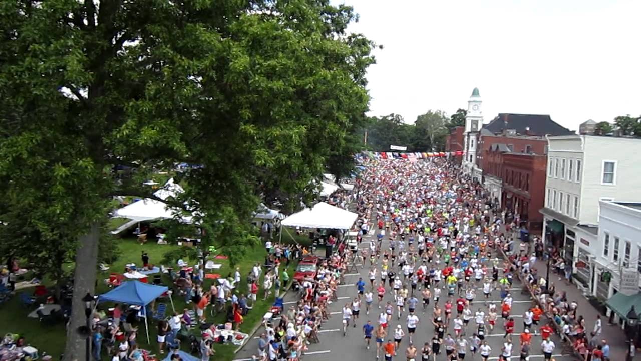
It is a race that begins, metaphorically and literally, with a bang.

While runners enjoy the quick start to the race provided by the downhill slope of West Street, it is the firing of a reproduction of an 1841 six-pound cannon by the First Litchfield Artillery that sends the 1,500 runners on their way.

While the First Litchfield Artillery registered itself with the Secretary of the State in 1964, they are the heirs to a long tradition of militia organizations in Litchfield. As late as 1851, all able-bodied men between the ages of 18 and 45 were required to serve in the militia.

Archeoparc_-_Palisade_1

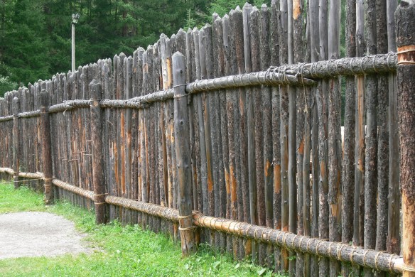
A modern reconstruction of a palisade.

The militia played an essential role in the town’s earliest days. From 1720 to 1730, five palisades – fences or walls made from wooden stakes that formed a secure enclosure –  offered defense for the town. These were located north, south, and east of the town, with a fourth in South Farms, the area of Litchfield that is now the town of Morris. The fifth palisade was at the site of the current courthouse, which runners pass immediately after the cannon fires. Legend holds that the widow Mercy Allen, one of the earliest settlers of town and the grandmother of Ethan Allen, helped build one of the palisades and manned it during threats of attack from Native Americans. Regardless of the veracity of the accounts of Mercy’s participation, members of the militia manned the palisades while townspeople worked in the fields and attended Sunday church services.

The defenses weren’t always successful. In May of 1722, Jacob Griswold was working alone in a field one mile west of the current court house when two Native Americans tackled him and carried him off to what is now North Canaan. Griswold, however, managed to steal a rifle from his captors while they slept, and made his way back to Litchfield. A mile or so north of town, he fired off the weapon, which warned the defenders in the nearby palisade of his plight. They helped ensure his safe return to town.

wolcott_oliverjr

Oliver Wolcott, Jr. Courtesy of Litchfield Historical Society.

Fifty-five years later, the presence of the British army in Danbury set off another alarm in Litchfield. The town’s militia was called out and sent south to drive out the king’s troops. Among those who participated was Oliver Wolcott, Jr., who was home from Yale. (Runners pass his home in the seventh mile.) His mother, Laura, sent him off with a blanket, a knapsack full of food, and an admonition to “conduct like a good soldier.” The Litchfield men encountered the British in a skirmish in Wilton, and helped force them to retreat.

2013-07-04 12.15.20 (2)

The modern-day artillery company is comprised of veterans who are United States citizens. Additionally, members are expected to be knowledgeable about Connecticut history. They work to preserve the traditions of horse-drawn artillery, participate in Memorial Day, Independence Day, and Veterans Day observances, participate in ceremonies at the request of the governor or the Connecticut Historical Commission, and help the governor uphold the laws.

Despite these lofty objectives, the artillery company is probably best known for sending nearly 1,500 runners through the streets of Litchfield.

For more information on the history of the Litchfield Road Race, see Lou Pellegrino’s forthcoming book A History of the Litchfield Hills Road Race: In Smallness there is Beauty. (Available May 2016)


Hidden in Plain Sight: The Walking Tour!

OLYMPUS DIGITAL CAMERA

The Litchfield Historical Society is sponsoring a walking tour based on this blog on Saturday, May 18th, at 10:00 a.m.  We’ll explore some of the sites previously discussed on these pages and share thoughts about some that will appear in the future.  The tour will focus on sites on the Litchfield Green and nearby South Street.  Visit the historical society’s website – http://www.litchfieldhistoricalsociety.org – for more information and for registration.

Hope to see you on the tour!

Revolutionary War Soldiers’ Tree

Rev war Tree 2

This small marker stands at the southeast corner of the eastern section of the Litchfield Green.

The first Arbor Day was held on April 10, 1872 and became an international event eleven years later when Birdsley Northrup of Kent, Connecticut, introduced the event to Japan.  However, Theodore Roosevelt’s ascendency to the presidency in 1901 and his emphasis on conservation issues sparked a nationwide surge of interest in Arbor Day.

In 1902 the Mary Floyd Tallmadge Chapter of the Daughters of the American Revolution celebrated the first Arbor Day of Roosevelt’s presidency by planting a tree on the Litchfield Green to commemorate the services of the town’s Revolutionary War soldiers.

Revolutionary War Soldiers

In all, 507 men from Litchfield served the Patriot cause between 1775 and 1783.  The first to serve were the men of the company led by David Welch of Milton, who were called up soon after news of Lexington and Concord arrived.  A second company enlisted in January 1776 to serve for the defense of New York City.  They drafted a contract specifying the terms of their service under Major General Charles Lee, stating that they were convinced of “the Necessity of a body of Forces to defend against certain Wicked Purposes formed by the instruments of Ministerial Tyranny.”  They specified, however, that they would not serve for more than eight weeks, and stated that General Lee had “given his Word and Honor” to uphold these terms.

fort washington

The Battle of Fort Washington

In November 1776 another company of Litchfield men under Captain Bezaleel Beebe set off for New York.  Thirty-six handpicked men of the company under Captain Beebe were sent to reinforce the American garrison at Fort Washington (today the Manhattan end of the George Washington Bridge).  The men marched into a trap, and were forced to surrender with the entire 2,600 man garrison of the fort.  Although the men were exchanged about a month later, only 11 of these men made it home to Litchfield.

In March 1777 a new call for troops went out, and Litchfield was tasked with enlisting 92 of its men.  The town voted to pay 12 pounds per year to each soldier and to supply “necessaries” to each soldier’s family.  A final call for troops reached town in 1781, and a “selective draft” took place, in which the town was divided into three classes and each class was expected to raise a certain number of men.

Interior of the Old Jersey Prison Ship

Interior of a British prison ship

In addition to those men who were killed and wounded in battle, twenty Litchfield men died while on the dreaded British prison ships.

Rev War Tree

Today, a small stone marker stands at the foot of the tree dedicated to these soldiers.  Its faded inscription reads:

Planted in Memory of

Litchfield’s Revolutionary Soldiers

by the

Mary Floyd Tallmadge Chapter

DAR

Arbor Day 1902

Litchfield’s National Historic Landmark Marker

Litch His D 3

On the southeast corner of the middle section of the Litchfield Green stands a stone marker with an engraved bronze plaque.  It reads:

Litchfield Historic District

Has been designated a

Registered National

Historic Landmark

Under the provisions of the

Historic Sites Act of August 21, 1935

This site possesses exceptional value

In commemorating or illustrating

The history of the United States

United States Department of the Interior

National Park Servce

1968

The United States government maintains a National Register of Historic Places identifying structures or locales significant in our nation’s history.  There are more than 85,000 places on this list.  Of those, only 2,430 have been designated as National Historical Landmarks.  These sites have been so recognized because they have been identified as possessing national-level historic significance.  Applications for such designation must meet one of six criteria:

·  Sites where events of national historical significance occurred;

·  Places where prominent persons lived or worked;

·  Icons of ideals that shaped the nation;

·  Outstanding examples of design or construction;

·  Places characterizing a way of life; or

·  Archeological sites able to yield information.

Litch His D 1

In the application for designation as a National Historic Landmark in 1967, Charles W. Snell wrote that “Litchfield is probably New England’s finest surviving example of a typical late 18th century New England town.”  He especially tied the district’s significance to the fifteen frame houses from the late 1700s and the three from the period 1800-1828 that still stood in the center of town.

OLYMPUS DIGITAL CAMERA

Snell further established that several of these houses were designed by William Sprat, a British architect turned soldier who was captured at Saratoga and who, as a prisoner of war, was brought to Connecticut.  He remained in the state after the war, renewing his architectural career.  Sprat was well known for his Late Georgian style, typified in Litchfield by the Julius Deming house and the Sheldon Tavern.

LHD_Litchfield_Borough_Map_TownWebsite

The Litchfield Historic District is defined by the National Park Service as including the east and west sides of North and South Streets to the rear property line, running from Prospect Street on the north to Gallows Lane on the south.  It also includes the building fronting the northeast side of the green, those structures from the Congregational Church to North Street.  In total, the district comprises about 20 acres.

north street 1906

North Street 1906

Architectural features were not the only feature of the town that impressed the National Park Service, who in their designation noted “the great elms which now form a broad and beautiful archway over North and South street.”  Thanks in part to this designation, 21st century residents and visitors see parts of Litchfield through in much the same way as those who lived here two hundred years ago.

Connecticut Highway Department Markers

Connecticut Highway Department marker near the Gooseboro drive-in in Bantam.

Connecticut Highway Department marker near the Gooseboro drive-in in Bantam.

There are among the most ubiquitous markers on our man-made landscape.  Usually between twelve and eighteen inches high, they are simple stone blocks engraved with the initials “CHD.”

A Connecticut Highway Department marker alongside Route 4 by the Torrington Country Club,

A Connecticut Highway Department marker alongside Route 4 by the Torrington Country Club,

“CHD” stands for the Connecticut Highway Department, a state agency that was incorporated into the Department of Transportation in 1969.  At one time, however, it was responsible for the construction and maintenance of all state roads.

CHD South Street 2

A Connecticut Highway Department marker abuts the sidewalk on the west side of South Street in Litchfield.

The Connecticut Highway Department began preparing highway boundary maps in 1926; much of the work was completed by the Works Progress Administartion during the Great Depression.  These maps were done in accordance with a statue passed in 1925 that required that the “Highway Commissioner … mark such boundary limits by a uniform and distinctive type of marker.”  The stone “CHD” markers satisfy this requirement.

CHD Litch Green 2

Three Connecticut Highway Markers denote the right of way to widen the turn along the northeast corner between the middle and eastern sections of the Litchfield Green. One marker is visible at the extreme right of the photo; a second is partially hidden by the tree at the front right; the third is visible between the telephone pole and tree in the background.

The highway department was originally created specifically to build highways.  By 1923, however, its tasks had expanded to eliminating dangerous conditions on roads, improving the roadsides, installing proper warning signs, removing snow and ice from the highways, and – pertinent to these markers – establishing boundary lines alongside the highways and securing the rights of way for the purpose of widening and straightening roads.

To oversee these last two tasks, the Connecticut Highway Department created the Bureau of Highway Boundaries and Rights of Way.  The bureau had three major tasks:  land titles, boundary surveys, and right of way purchases.  When it was determined that a new road needed to be built, the bureau conducted a title search, acquired the property and was charged with “properly marking the boundaries of all state roads” (Forty Years of Highway Development in Connecticut, 16).  The result of this, of course, are the thousands of stone markers that dot Connecticut roadsides.

The stone “CHD” markers have interesting stories to tell to those explorers willing to look into them.  The “CHD” marker above is on Prospect Street, a town road, not a state road,  However, a look at an old map shows that this was once the site of “Wolcott Road.”  While this road was subsequently closed, the right-of-way is still maintained by the state.

These stone markers are a thing of the past, however.  Today, the Connecticut Department of Transportation marks its property flush to the ground, with bronze discs engraved with “CTDOT.”