Photos from Litchfield’s Court House

The Litchfield Court House ceased operations in August 2017 after operating in town since the 1750s and in the same building since it was constructed after the fire of 1886. The Greater Litchfield Preservation Trust, which recently purchased the building, held an open house for a glimpse inside the historic structure.

IMG_7863

View of the town green from the second floor

IMG_7862

A fireplace in one of the offices.

IMG_7861

Entrance to the large law library on the second floor.

IMG_7860

Entrance to one of the judge’s chambers

IMG_7859

Witness stand in one of the courtrooms

IMG_7858

Second floor courtroom

IMG_7857

Seth Thomas clock in one of the courtrooms

IMG_7856

A holding cell in the basement


Advertisement

Hidden Nearby: North Goshen Methodist Episcopal Church Marker


img_7513

The Methodist Episcopal Church was an outgrowth of the Great Awakening, a colonial American religious movement within the Church of England that emphasized being born again and attaining Christian perfection. Additionally, the Methodist Episcopal ministers and congregants tended to be both anti-elitist and anti-slavery.

Image result

John Wesley

John Wesley, who along with George Whitefield founded Methodism, ordained the first American Methodist Episcopal ministers in 1784. Methodists in most Litchfield County towns continued to attend Congregational services until they could build a church of their own. This was the case in the community of North Goshen; however, when – in 1840 –  the Methodists in that area expressed a desire to build their own church, the Congregationalists contributed to their cause.

img_7511

That church stood at what is now the intersection of East Street North and North Goshen Road. As towns were often created when a significant number of people no longer wanted to travel far for religious services (Morris was carved out of Litchfield and Washington out of New Milford, Litchfield and Woodbury for this reason), the presence of this church suggests that while this area is now quite remote, it was once a vibrant community. In fact, the “History of the Town of Goshen” states that the church “flourished and at the congregation at times filled the church to overflowing.”

That 1897 history, however, also states that in later years the church’s numbers and finances were “greatly reduced,” leading the congregation to accept attendees from other churches and to be “very liberal to all sects, and Adventists, Unitarians, Baptists, and Congregationalists have preached to us but we like the ‘good Old Methodists’ the best.” The North Goshen Church closed 1920, less than two decades before the 1939 merger between the Methodist Episcopal Church and the Methodist Protestant Church, which formed the United Methodist Church.


Hidden Nearby: An Autumn Walk to Steep Rock’s Quartz Mine

As with many of our other protected lands (Lover’s Leap State Park, Burr Pond State Park, the White Memorial Foundation), the Hidden Valley Preserve of Washington’s Steep Rock Association was once the site of industrial operations. The Hidden Valley, quiet today except for the sound of the rushing Shepaug River, once echoed with the sounds of quartz mining and locomotives. The glories of a New England Fall presents the perfect time to visit this piece of Litchfield County’s industrial heritage.

IMG_6713

A short walk along the northwestern bank of the river brings the hiker to the spectacular Thoreau Bridge, erected in 2015.

IMG_6683

Quotes from Thoreau are emblazoned on the bridge.

IMG_6704

On the eastern bank of the Shepaug River is this monument and bridged dedicated in honor of Washington native and West Point graduate Stephen Reich, killed in Afghanistan in 2005. 

IMG_6700

The trail passes old footpaths, cart paths, and the bed of the railroad used to haul the quartz out of the area, often to the Hudson River.

IMG_6707

Stone retaining walls in the woods mark the old road beds used to get wagons and carts to the mine.

IMG_6708

Fragments of quartz line the trail approaching the mine.

IMG_6709

The quartz itself, a surface mine in operation from the 1800s to 1905.


Quartz, the most common mineral on the earth’s surface, was an important industrial product in American history. Initially quartz was used for knives, scrapers, and arrowheads. With the coming of the industrial revolution, the uses of quartz changed. It was pulverized and used as a filler in paints. (The Bridgeport Wood Finishing Company, a major paint-making operation, was located just a few miles away along the Housatonic in New Milford.) Another use of quartz was as an abrasive, like sandpaper. The primary use of quartz, however, was for glass, which is essentially melted quartz.


The hiker needs no excuse to travel to the beautiful woods of the Hidden Valley, but keeping one’s eyes open reveals a rich part of the county’s history.


Wild Garden Monument

garden2

What might appear to be Litchfield’s newest monument is simply an older one, once again back in sight.

In 1922, the White Memorial Foundation leased 150 acres east of Little Pond to the Litchfield Garden Club for the “creation and maintenance of a wild garden containing trees, shrubs and flowers native to Connecticut and to Litchfield County.”  (The Garden Club paid $1.00 to lease the land for ten years.) Trails were opened allowing visitors to access the gardens and Little Pond, and the Sutton Bridge was built to cross the Bantam River.

Wild Garden Map

A 1932 map showing the Litchfield Wild Garden. The Sutton Bridge appears at the bottom. “Map of the Litchfield Wild Garden” Litchfield Historical Society, Helga J. Ingraham Memorial Library. Thanks to Linda Hocking at the Litchfield Historical Society for providing the digital image.

One trail began at the intersection of Old South Road and Gallows Lane, and there the Garden Club placed a monument to greet visitors. It read:

The kiss of the sun for pardon,                                                                                                     The song of the birds for mirth,                                                                                                           One is nearer God’s Heart in a garden                                                                                       Than anywhere else on earth.

The lines are from the poem “God’s Garden” by English poet Dorothy Frances Gurney (1858-1932), and are commonly found on plaques in gardens.

garden1

In 1975, the Wild Gardens reverted back to White Memorial, and the small plot of trees at the intersection of Old South and Gallows soon engulfed the monument. Recently, however, it has been been brought back into view, and while several words are missing from the poem, it remains a tribute to the splendor of the natural world that surrounds Litchfield.

The Residence of Charles D. Wheeler

wheeler home

Charles D. Wheeler (1817-1895) was a Litchfield farmer who built this home on what is now Hutchinson Parkway (named for Isaac Hutchinson, Wheeler’s son-in-law) around 1840. With its gables emulating pediments and its pilasters, it is representative of the Greek Revival style of architecture. The home still stands, and its barns are cataloged in Historic Barns of Connecticut.

This illustration appeared J.W. Lewis’s 1881 History of Litchfield County, Connecticut. Those with a careful eye might notice the hitching posts and carriage steps along the white picket fence. Such vestiges of a bygone era of transportation still dot Litchfield’s landscape, including these on North Street:

2013-08-06 12.05.47

IMG_2532

Hidden Nearby: The U.S.S. Pittsburgh Bell in New Milford

The monument in Honor of Admiral Henry Shepard Knapp on the New Milford green.

A granite shaft with a bell adorning it stands at the center of the New Milford green. It honors an American naval officer with deep family ties to the town.

Henry Shepard Knapp was born in New Britain in 1856, and graduated from the United States Naval Academy in 1878. He served in the navy for the next 42 years. Gaining combat experience in the Spanish-American War, in 1908 he was given command of his own ship, the cruiser U.S.S. Charleston. In 1915, Knapp was named to command the U.S. Atlantic Fleet, and in 1916 he proclaimed the American occupation of the Dominican Republic, of which he would be named the military governor in 1917. He was promoted to rear admiral a week before World War I broke out.

During the war, Knapp was commanded American efforts to protect shipping from German U-Boats and was awarded the Navy Cross for this “meritorious service.” After the armistice Knapp served as naval attache in London, then commander of all American naval forces in European waters. During this time the U.S.S. Pittsburgh served as his flagship. He retired in 1920 but was so highly esteemed that he was kept on as a consultant and unofficial diplomat in handling crises in Haiti and the Dominican Republic and taught summer courses at the United States Naval Institute until his death in Hartford in 1923.

The bell of the U.S.S. Pittsburgh. It is interesting to note from the inscription that the bell had been used on a ship before, the Steamer Pensacola, which was commissioned in 1859 and decommissioned at Mare Island Navy Yard in California (visible on the bell) in 1911, a year before the Pittsburgh was commissioned. 

In 1951, New Milford’s Ezra Woods Post 31 of the American Legion erected the monument to Knapp on the town green. (Woods was New Milford’s first resident killed in World War I.) Knapp had owned property in town – including a commercial building on Bank Street – and spent summers in  New Milford at the family’s ancestral home.

In 1956, the Knapp house was donated to the New Milford Historical Society by Mary Clissold Knapp in 1956. This was the house of cobbler Levi Knapp who purchased it from Royal Davis in 1838. Parts of the house date to 1770, while much was of it was built in 1815. The house stands at the northern end of the green on the historical’s society’s property.

Image

Knapp’s flagship, the U.S.S. Pittsburgh. Not that the caption states the name as the Pennsylvania. The ship’s name was changed in 1912 so that Pennsylvania could be used for a new battleship.

Knapp’s flagship, the Pittsburgh – on which the bell once rang – was a 504 foot long cruiser, armed with 54 guns and when fully manned had a crew of nearly 900 men.  The New Milford monument is not the only memorial to Knapp’s service to the U.S. Navy. In 1943, the WWII destroyer USS Knapp was named for him


Hidden Nearby: The Torrington Savings Bank

Alexander Hamilton (1755? to 1804), first United States Secretary of the Treasury

Alexander Hamilton’s envisioned an economic future for the United States in which the fledgling country would soon rival the great powers of Europe in industrial production. The introduction of factories to the new nation was dependent upon banks that could provide access to the money needed to fund such undertakings. The result was the Bank of the United States, which was chartered in 1791, and operated until its charter expired – and was not renewed – in 1811. Five years later the Second Bank of the United States was created by Congress and President James Madison. However, an extension of its charter was vetoed by Andrew Jackson in 1832, leading to the transfer of the Bank from federal to state control in 1836.

A political cartoon critical of Jackson’s 1832 veto of the charter of the Second Bank of the United States.

In the wake of the collapse of the Second Bank of the United States in 1836, banks across the country struggled with fraud, counterfeiting, and the lack of access to banks for many Americans. Banks were banned altogether in Wisconsin. In the states of the Northeast, where banking continued with few interruptions, industry thrived. This was not the case in other parts of the country. The National Banking Act of 1863 hoped to ensure consistent regulation of banks – and thus, consume confidence – across the country. This was especially important in the midst of the Civil War, as banks were the major purveyors of war bonds. With access to capital restored, American industry was poised to explode.

bank

This formed the backstory to the founding of the Torrington Savings Bank. Originally chartered as the Wolcottville Savings Bank in 1868, its first location was in the Granite Block, opposite today’s Warner Theatre. Francis Holley was the first president of the bank. In 1881, the bank changed its name to the Torrington Savings Bank. In 1938, the bank moved to its present headquarters, at the corner of Main Street and Mason Street, which had previously been the site of the George S. Weeks Grocery.

The Torrington Savings Bank, built 1938. Photo courtesy of Torrington Historical Society

The noted American architect Louis Sullivan (1856-1924) famously said that in architecture, “Form follows function.” This is evident in architect Carl Victor Johnson’s design, in which the sturdy brick and stone design is offset by colonial revival architecture, reminding passersby of the bank’s New England roots.

For more on the history of the Torrington Savings Bank building – and an excellent source for the history of Torrington – be sure to check out the Torrington Historical Society’s “Audio Walking Tour of Downtown Torrington.”

For more on the history of counterfeiting in Litchfield County, see my book, Wicked Litchfield County.

Hidden Nearby: North Canaan’s Monument to the Convention Army’s March

march1

The monument to the Convention Army’s march, “the Revolution’s longest” on Sand Road in North Canaan.

My last post featured the sign in Southbury commemorating the march of General Rochambeau’s French army across the southern border of the county during the Revolutionary War. A second Revolutionary War army had traveled across the northern edge of the county three years earlier. This march is commemorated by a marker along Sand Road in North Canaan.

Surrender of General Burgoyne by John Trumbull. The original hangs in the Rotunda of the United States Capitol.

Following the victories of the American army at Saratoga in September and October 1777, British General John Burgoyne surrendered his army of about 6,000 men on October 17th. The terms of the surrender – known as the Saratoga Convention – stated that these British soldiers were to be paroled upon a promise to never fight against the Americans again. As the terms required approval by King George III, the British prisoners were marched to Cambridge, Massachusetts, to get them away from the approaching Adirondack winter. They arrived there in early November, taking up quarters that had been built by the British in 1775. Many of these men were sent to work for local farmers during the day. Approximately 1,500 British escaped, as legend holds that they became romantically involved with the daughters of these farmers.

Related image

A Viginia historical marker commemorating the end of the Convention Army’s march in Charlottesville.

In November 1778, with the terms of the convention still unratified and with Burgoyne refusing to provide a list of names of his officers so that Americans could ensure they would not fight again, the terms of the convention were revoked. The remaining British soldiers departed Boston, bound for Charlottesville, Virginia. This was, as the monument in North Canaan testifies, the longest march of the Revolutionary War. Entering Connecticut at Suffield, the British (and German Hessian) prisoners and their American escorts passed through Litchfield County’s Barkhamsted, New Hartford, Winchester, Colebrook, Norfolk, North Canaan, Salisbury and Sharon. A separate column comprised primarily of the Hessian soldiers passed through Kent and New Milford as well. In Sharon, A detachment of Hessians reportedly camped on the Norfolk green, where one prisoner escaped, married a local woman, and settled down. Other Hessian soldiers encamped opposite the Stone House (along what is now Stone House Road), where local residents long remembered the soldiers singing devotional songs in German.

march2

For more on the Convention Army, see this excellent post by Tim Abbott.


Hidden Nearby: Rochambeau’s March through Southbury

southbury1

Following the great American victory at the Battle of Saratoga in October 1777, Benjamin Franklin negotiated an alliance between the fledgling American nation and France. Motivated by a desire to weaken their British adversaries, and convinced that the Americans could not defeat the British with only foreign financial aid, in January 1780 France reversed its policy to not send ground troops to assist the Americans. In July 1780, General Jean Baptiste Donatien de Vimeur, comte de Rochambeau, arrived at Newport, Rhode Island, with and army of approximately 6,000 men. Two months later, Rochambeau traveled to Hartford to meet with Washington, who desperately wanted to French to aid him in his plan to assault New York City. However, even Washington was forced to admit that it was too late in the year to carry out such an operation.

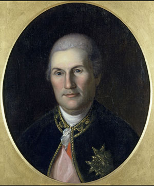
Jean Baptiste Donatien de Vimeur, comte de Rochambeau (1725-1807)

Jean Baptiste Donatien de Vimeur, comte de Rochambeau

Jean Baptiste Donatien de Vimeur, comte de Rochambeau


In May of 1781, the two generals met again, this time in Wethersfield. (Note: It was for these two meetings that Washington traveled through Litchfield County, likely crossing Bull’s Bridge in Kent, resting under the Washington Oak in Gaylordsville, and spending the night in Litchfield.) Here, they decided that Rochambeau would indeed move his army to Westchester County, to cooperate with Washington in an attack on the British garrison of New York City. The line of march would bring them across Connecticut, a route known today as the Washington-Rochambeau Revolutionary Route, administered by the National Park Service.

soutbury-2

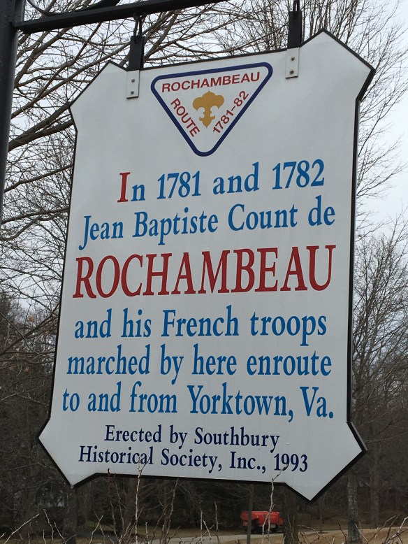
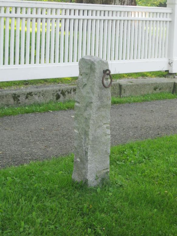
Rochambeau’s forces began their march out of Rhode Island on June 18th. The general’s plan called for the men to march 12 to 15 miles a day. To avoid the heat of mid-day, the troops awoke at 2:00 am, and were on the march by 4:00 am. Marching was typically completed between 8:00 am and noon, at which time the men pitched their tents. The French army were treated as heroes by the Connecticut populace, who greeted them with music and dancing, and French soldiers long remembered the “beautiful maidens” they met on the march. Around June 30th, Rochambeau’s marched through Southbury, an event commemorated by the above marker. While this marker is situated between Route 6 and Mansion Hill Road, a National Park Service map indicates that Rochambeau’s forces did not take this route, instead picking up Route 6 further south.

Jonathan Trumbull’s Surrender of Lord Cornwallis. Rochambeau is the 12th (final) figure on the left side. The British general Charles O’Hara, tasked by Cornwallis with surrendering the army, initially offered his sword to Rochambeau, who refused in deference to Washington. Washington also refused, and directed O’Hara to surrender his sword to Benjamin Lincoln (on the horse at center), who had previously been humiliated by the British at Charleston.


Washington personally reviewed the French force after their arrival in Westchester on July 6th. After considerable discussion about how best to attack the British in New York City, the arrival of a French fleet off the Virginia coast compelled the two generals to change their plans and focus on the British force under Lord Cornwallis at Yorktown. Within a few months, Cornwallis had surrendered, the world was turned upside down, and the Americans were on their way to independence. It was thus a victorious French army that marched back through Southbury in 1782, having done much to ensure American independence.

For more information on Rochambeau’s march, check out the National Park Service’s excellent brochure: https://www.nps.gov/waro/learn/news/upload/WARO-brochure-both-sides-2.pdf


DAR’s Memorial Window at Litchfield Historical Society

marker

One of Litchfield’s newest markers (along with the War on Terror monument on the green) was dedicated in September 2016. It commemorates the dedication of a stained glass window in the north side of the Litchfield Historical Society.

img_5187-3

The window was dedicated in 1907 by the Mary Floyd Tallmadge Chapter of the Daughters of the American Revolution as a memorial to the more than 3,000 men from Litchfield County who served in the War for Independence. For more on the service of these men, click here.

Image result for frederic crowninshield

Frederic Crowninshield (1845-1918)


The Mary Floyd Tallmadge Chapter was founded as an independent branch of the DAR in 1899. Prior to that, it had existed as an adjunct of the Judea (Washington) Chapter. Elizabeth Barney Buel, the first regent of the chapter, spearheaded the effort to place a memorial stained glass window in the Noyes Memorial Building, which at the time housed both the historical society and the town’s library. It required considerable fund raising, both for the execution and installation and for the services of artist Frederic Crowninshield, who was president of the Fine Arts Federation and former instructor at Boston’s Museum of Fine Arts School of Drawing and Painting. Crowninshield is perhaps best known for his stained glass window Emmanuel’s Land , depicting a scene from Pilgrim’s Progress, in Boston’s Emmanuel Episcopal Church.

fullsizerender-2

Crowninshield’s design for Litchfield depicts a young man with a sword in his right hand and a laurel branch in his left, symbolic of victory in the war. The full beauty of the artist’s design is visible when the window is illuminated at night.


Image result for litchfield historical society

The Noyes Memorial Building, Litchfield Historical Society. The Revolutionary War Soldiers Memorial Window is at the far right of this picture.


In 1964, the library moved from the Noyes Memorial Building (named for Julia Tallmadge Noyes, a granddaughter of Mary Floyd Tallmadge) to its current location in the former home of Oliver Wolcott, Jr. This allowed for the Litchfield Historical Society to occupy the entire building on the corner of South and East Streets, where the young man with drawn sword in the window can guard the town’s history.