The Northfield Knife Shop

knife shop dam

A recurring theme of this blog has been that street names have a lot to tell us.

Mill pond
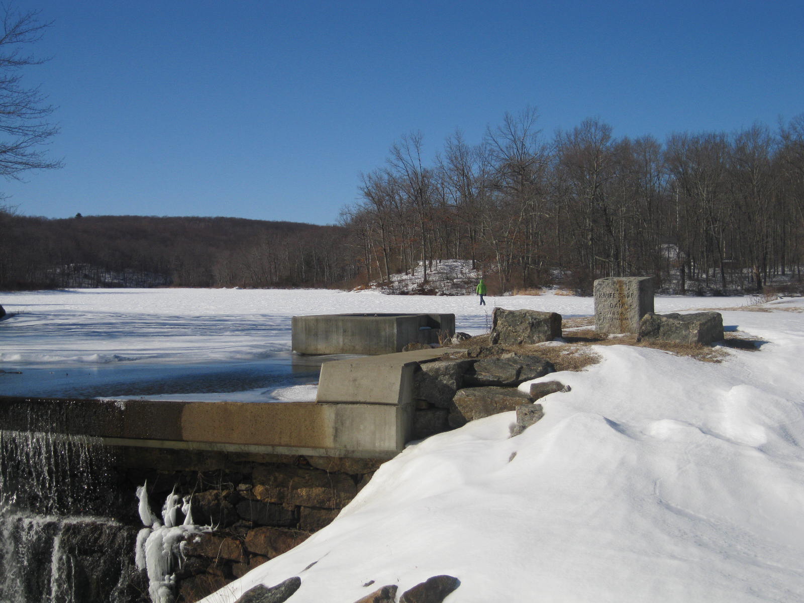
Such is the case with Northfield’s Knife Shop Road.  Here, on the Humiston (or Humaston) Brook mill pond, once stood Litchfield’s largest business.

Northfield_Knife_Factory_Northfield_CT-690x405
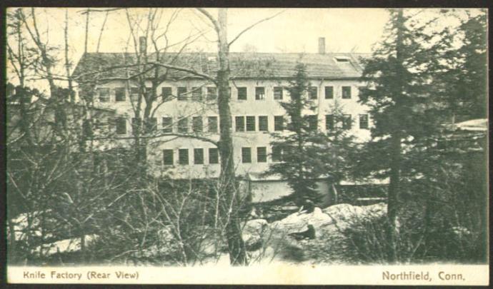
The Northfield Knife Company was established in 1858, taking advantage of the water power and access to the Naugatuck Railroad.  In the post-Civil War era the company produced over 12,000 knives per year.

000_2242It employed 120 workers, many of whom were highly trained experts from Sheffield, England, then world-renown for its excellence in steel-knife production.  (In fact, when a proposal was made in 1866 to incorporate Northfield as a separate town, one opponent argued before the state legislature that the English cutlers weren’t fit to be citizens of a town!)

foundation

Foundation of the the knife shop complex.

The mill dam brought other businesses to Northfield as well, most prominently a feed and fertilizer mill run by Jeremiah Peck.  The growth of these two businesses led to a corresponding growth in Northfield’s population, and factory housing appeared in town.  In 1865, for example, the Northfield Knife Company spent $5,000 to erect five homes for employees on Main Street.

northfieldknifeoct41884ironagead
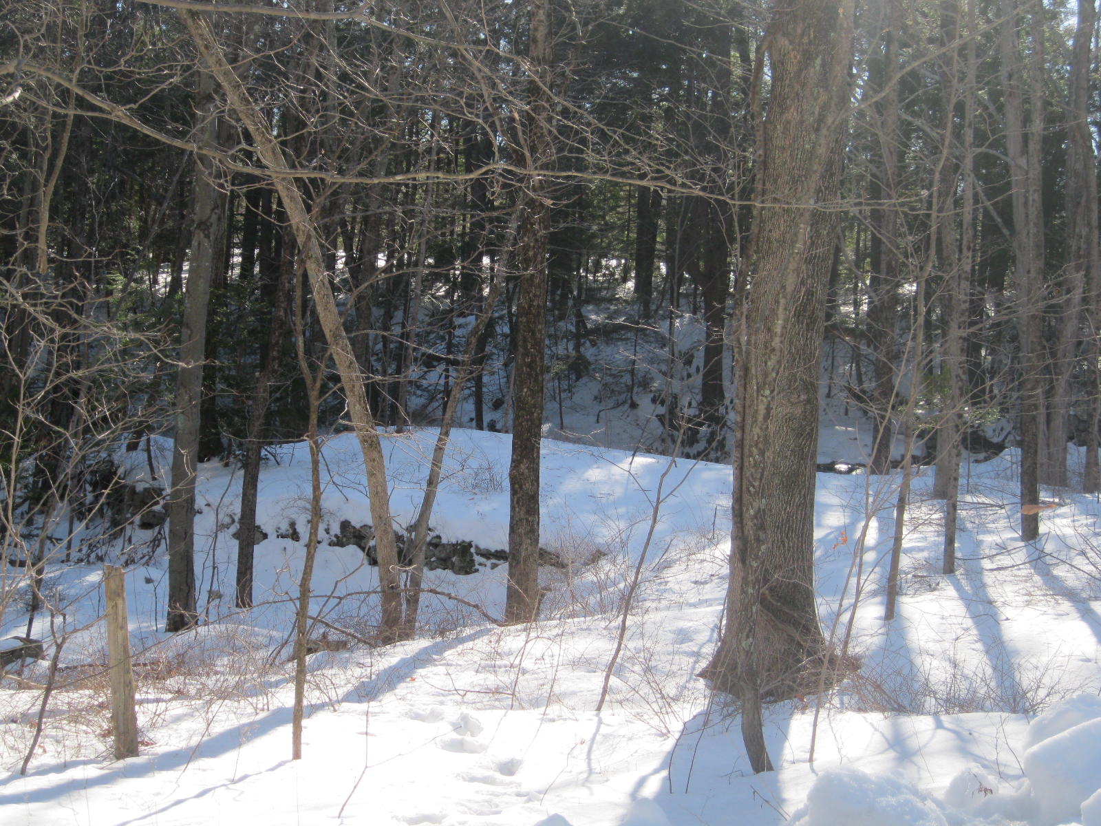
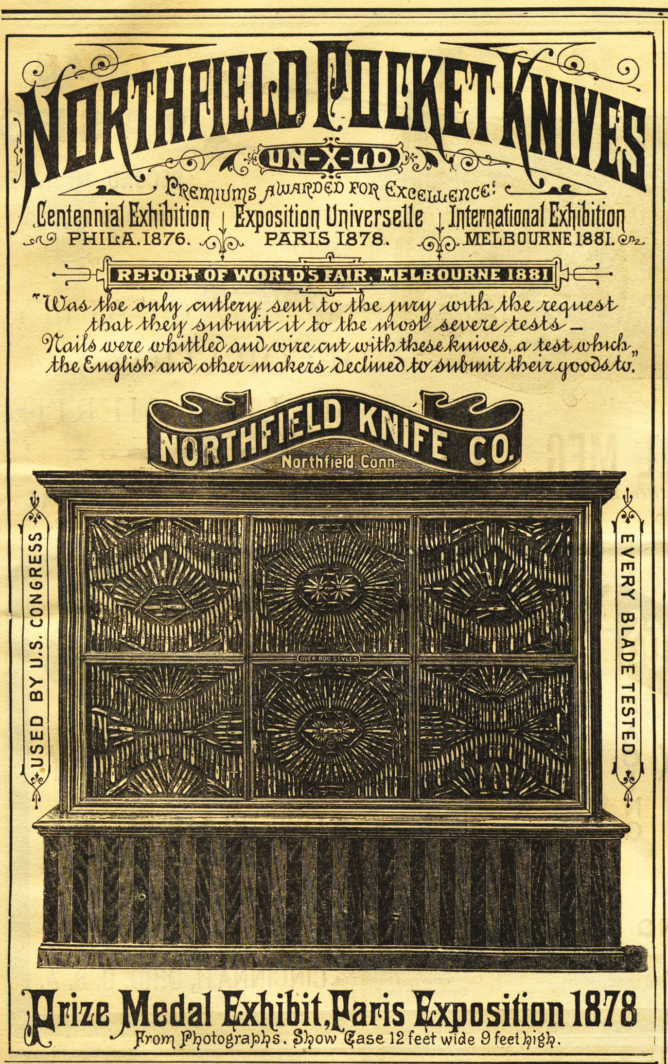
Northfield knives live on as Northfield UN-X-LD, a division of Great Eastern Cutlery.  Today they are made in Titusville, Pennsylvania.  The mill pond in Northfield remains, however, testimony to the industrial heritage of this area and to the Northfield Knife Company, an internationally-known business whose knives were featured at the 1893 World’s Columbian Exposition in Chicago.

Much of the information presented on Northfield’s industrial history is derived from Rachel Carley’s excellent  Litchfield:  The Making of a New England Town.

Connecticut Highway Department Markers

Connecticut Highway Department marker near the Gooseboro drive-in in Bantam.

Connecticut Highway Department marker near the Gooseboro drive-in in Bantam.

There are among the most ubiquitous markers on our man-made landscape.  Usually between twelve and eighteen inches high, they are simple stone blocks engraved with the initials “CHD.”

A Connecticut Highway Department marker alongside Route 4 by the Torrington Country Club,

A Connecticut Highway Department marker alongside Route 4 by the Torrington Country Club,

“CHD” stands for the Connecticut Highway Department, a state agency that was incorporated into the Department of Transportation in 1969.  At one time, however, it was responsible for the construction and maintenance of all state roads.

CHD South Street 2

A Connecticut Highway Department marker abuts the sidewalk on the west side of South Street in Litchfield.

The Connecticut Highway Department began preparing highway boundary maps in 1926; much of the work was completed by the Works Progress Administartion during the Great Depression.  These maps were done in accordance with a statue passed in 1925 that required that the “Highway Commissioner … mark such boundary limits by a uniform and distinctive type of marker.”  The stone “CHD” markers satisfy this requirement.

CHD Litch Green 2

Three Connecticut Highway Markers denote the right of way to widen the turn along the northeast corner between the middle and eastern sections of the Litchfield Green. One marker is visible at the extreme right of the photo; a second is partially hidden by the tree at the front right; the third is visible between the telephone pole and tree in the background.

The highway department was originally created specifically to build highways.  By 1923, however, its tasks had expanded to eliminating dangerous conditions on roads, improving the roadsides, installing proper warning signs, removing snow and ice from the highways, and – pertinent to these markers – establishing boundary lines alongside the highways and securing the rights of way for the purpose of widening and straightening roads.

To oversee these last two tasks, the Connecticut Highway Department created the Bureau of Highway Boundaries and Rights of Way.  The bureau had three major tasks:  land titles, boundary surveys, and right of way purchases.  When it was determined that a new road needed to be built, the bureau conducted a title search, acquired the property and was charged with “properly marking the boundaries of all state roads” (Forty Years of Highway Development in Connecticut, 16).  The result of this, of course, are the thousands of stone markers that dot Connecticut roadsides.

The stone “CHD” markers have interesting stories to tell to those explorers willing to look into them.  The “CHD” marker above is on Prospect Street, a town road, not a state road,  However, a look at an old map shows that this was once the site of “Wolcott Road.”  While this road was subsequently closed, the right-of-way is still maintained by the state.

These stone markers are a thing of the past, however.  Today, the Connecticut Department of Transportation marks its property flush to the ground, with bronze discs engraved with “CTDOT.”

The Intersection of North and South Streets

A common theme of this blog has been that we can learn a lot more about our historical landscape by getting out of our cars and taking the time to explore our surroundings.  Some things, however, are eminently clear even from behind the wheel of a car.  Most of those reading this post have sat at the red light at the intersection of routes 63 and 202, looking to proceed from North Street to South Street.  It is clear to all motorists that to do so requires a left turn on to West Street, then a right turn on to South Street.  Why are North and South Street not aligned?

An 1814 map of Litchfield, showing the alignment of North and South Streets. From Rachel Carley, Litchfield: The Making of a New England Town

North and South Streets are among the oldest streets in town, and historian Rachel Carley reports that landscaping of these streets began as early as 1771.  An 1814 map records these streets as being “very wide”, while another source states that the streets resembled “long pastures.”  At town meetings in 1771 and 1785, it was decided to straighten North and South Streets.

Nathaniel Hawthorne

Nathaniel Hawthorne visited Litchfield in 1838, and marveled at the width of the streets, and the islands of grass that divided the thoroughfares.  He wrote that “nothing can be neater than the churches and houses” along the two streets.

An alder swamp

This was, however, not always the case.  Alain White, in his history of Litchfield, states that the likely reason for the wide streets was “more for the convenience of the cattle than the delight of residents and strangers.”  White further reports that the awkward alignment of North and South Streets may have been due to an alder swamp along the west side of South Street, which forced that street to be moved a few yards to the east.    However, White also recounts that the zig-zag of the two streets might have been due to the presence of a stately oak, “so beautiful that the settlers laid out North Street … to the west to avoid having to cut it.”  There is a third possibility.  The paths of the two streets follows the crest of the ridge on which they were built.  This was likely the route of the earliest footpaths in town, and it simply may have been more convenient to blaze the roads along the same lines.

There is one other interesting note about the layout of North and South Streets.  It was common in colonial New England town to lay out the streets on the lines of the cardinal directions.  Litchfield is unique only in that those streets – North, South, East, West – have retained their directional names.  However, North Street is not aligned to 0 degrees, but rather to 13 degrees.  This is a result both of the original layout of the street – it was, for whatever reason, not aligned to true north – as well as the fact that magnetic north has moved approximately five degrees to the northeast since they town was laid out in the early 1700s.

Connecticut Tercentary Signs

Travelers entering Litchfield from the west encounter this tercentary sign as they pass Stop and Shop.

In 1935, Connecticut celebrated the tercentenary of its European settlement. It was an enormous undertaking, with over 3,000 events attended by more than 4 million people (the total population of the state was 1.6 million,which ranked it 29th in the country; in 2012, with 3.5 million residents, Connecticut still ranks 29th!).


The State Legislature created the Connecticut Tercentary Commission in 1929 to plan and oversee the commemoration.  Among its sponsored activities were special exhibits and ceremonies, musical events, pageants and parades, activities for schoolchildren, and special license plates.  Special coins were minted, and special stamps created.


Two undertakings of the Commission continue to serve their original purpose more than three quarters of a century later.  The first is the series of sixty pamphlets on Connecticut history published by Yale University Press for the Commission.  These pamphlets, authored by various Connecticut writers including Commission chairman Samuel Herbert Fisher, are all available at the Connecticut State Library.  Of particular interest to Litchfield are The Settlement of Litchfield County, The Litchfield Law School, 1775 – 1833, and Connecticut Portraits by Ralph Earl.

The east side of the sign between Stop and Shop and the Webster Bank. It bears Connecticut’s state motto, which translates to “He who transplanted still sustains” and the state seal, which shows three grapevines, one representing each of Connecticut’s three earliest settlements, Windsor, Wethersfield and Hartford.

More noticeable on the Litchfield landscape are the roadside historical markers erected by the Commission.  Thousands of cars pass Litchfield’s four signs every day, yet there is no indication on the signs about who put them up, when they were put up, or why.  There were 139 known signs erected to inform motorists about important episodes or people from Connecticut history.  However, as many of these signs were duplicate (for example, nine signs in Hartford told the passerby about a nearby 17th Dutch fort), there were 71 different historical sites marked by the Commission.

The west side of the sign located between Stop and Shop and the Webster Bank.

All the signs were 1.5 feet by 2 feet, and painted in the distinctive brown with white letters.  However, while most hung from poles, there was no uniform method for hanging the markers.

It is interesting to ponder, what sites were marked? What sites weren’t? In keeping with the historiographical attitudes of the time, it is not surprising to learn that many identified sites of military importance.  However, eleven of the signs identified sites of educational importance, and sites of literary importance were also well represented.  Litchfield’s markers reflect these trends.

This sign marking the Beecher homestead is located at the intersection of North Street and Prospect Street.

Signs mark the Litchfield home of the literary and theological Beechers …

Located along North Street. Note: If any town officials are reading, the tree around this sign needs to be trimmed!

… and Litchfield’s educational pioneers Sarah Pierce …

Located in front of the Tapping Reeve Home and Law School on South Street.

… and Tapping Reeve.  Yet no signs (at least no extant signs) mark the sites of homes of Revolutionary heroes Oliver Wolcott or Benjamin Tallmadge, further evidence that what is considered significant in history changes over time, and isn’t always cast in stone, or metal.

Alain and May White Memorial Boulder

Here is among the most hidden in plain sight of Litchfield’s many monuments and markers.  How many hundreds, if not thousands, of hikers and bikers pass by this engraved boulder near the intersection of White Memorial’s Mattatuck and Beaver Pond trails without seeing it?

The boulder honors two of Litchfield’s most distinguished residents, Alain (1880-1951) and Margaret “May” (1869-1941) White.  Together they preserved nearly 9,000 acres of land that today comprise the White Memorial Foundation, Mohawk State Forest and Mohawk Mountain State Park, Kent Falls State Park, Macedonia Brook State Park, the People’s State Forest, Campbell Falls State Park, and portions of the Steep Rock Preserve.

The Whites were the children of John Jay White, a New York City real estate magnate who built Whitehall, a Victorian summer estate in Litchfield that today is the main building of the White Memorial Foundation.  Alain was educated as a botanist at Harvard in the era of Theodore Roosevelt’s presidency, a combination that may have led to his first impulses of conservation.  (It is interesting to note that White was a champion chess player, who is credited in some circles with breaking the German code in World War I, which was based upon a pattern of chess moves.)

Fishing the Bantam River with his friend William Mitchell Van Winkle in 1908, Alain commented “Wouldn’t it be wonderful to preserve this river, lake and countryside as we see it now?”  With his sister May he would devote nearly the next half century to acquiring additional lands for a preserve dedicated to the memory of their parents, including the Babbit farm along today’s Route 63, on which this boulder stands.

Their goal was not simply to allow nature to run its course on these lands, however; rather, they hoped to “make shoreline available for youth camps, simple vacation home and convalescent retreats” (Rachel Carley, Litchfield, p. 225).  This, then, was practical conservationism.  Nor were their philanthropic impulses limited to nature; Alain was deeply involved in the establishment of the Connecticut Junior Republic, and in fact collaborated with Cass Gilbert, the architect of New York’s famed Woolworth Building, on its design.  He also wrote a detailed history of Litchfield in 1920.

May was a Sunday school teacher and avid theater aficionado who began a series of children’s performances at Whitehall, and who worked to turn the Lakeside Hotel into a summer getaway for children from New York City, a forerunner of the Fresh Air Fund.


Still, they are rightly best remembered today for their remarkable contribution of a 4,000-acre backyard for Litchfield, a refuge not only for animals but for hikers, bikers and kayakers.  As real estate development infringes upon more and more open spaces, the words carved on the boulder are increasingly appropriate:

In most grateful memory of

ALAIN AND MAY WHITE

brother & sister who loved

the quiet and beauty of the

forest and who saved these

thousands of acres for us.

To find the monument, park in the small parking area near the intersections of Routes 63 and 61.  Walk east on the Beaver Pond Trail (white blazes) until the trail intersects with the Mattatuck Trail (blue blazes).  Follow the fork to the left, the Mattatuck Trail.  The monument will soon appear, set in the woods on your left.

Jedediah Strong’s Milestone

It’s easy to miss.  Traveling past Litchfield Bancorp on Route 202, the modern motorist is often too concerned with navigating traffic to notice the small marker on the bank’s lawn.  However, when it was erected 225 years ago, travelers only as fast as their horse or feet could take them almost certainly saw the engraved stone:

33 miles to Hartford

102 miles to New York

J. Strong AD 1787

It remains today, a reminder of the ingenuity of early Americans as well as one Jedediah Strong, one of Litchfield’s more unusual characters.

Roman milestone

Milestones have existed since at least Roman times, and dozens of milestones – bearing the name of the emperor under who rule they were erected and the distance to Rome – remain scattered across what was once the Roman Empire.  Milestones serve to mark the route and distance to a site.  As such, they provided reassurance a traveler that he was on the right road, and gave him an idea of how much longer his journey would last.

Franklin’s odometer

In our age of satellite navigation and laser-guided surveying, it is interesting to ponder how these measurements were made in a much simpler time.  Assuming that Jedediah Strong measured these distances himself, he likely did it by attaching an odometer to one of the wheels of his wagon.  The Romans possessed this technology, but like many of their innovations, it was lost as Europe entered the so-called Dark Ages.  The technology was rediscovered by Benjamin Franklin who, as Postmaster General, was desirous of knowing the shortest routes for sending the mail.  His odometer kept count of the number of revolutions made by the wagon wheel; by multiplying the number of revolutions by the circumference of the wheel, he arrived at the distance traveled.  (Incidentally, Google Maps states that the distance from Strong’s milestone to Hartford is 33.1 miles, and to the Bowling Green in Manhattan is 101 miles, testimony to the accuracy of the odometers of the time.)

Jedediah Strong was born in Litchfield in 1738, and graduated from Yale College in 1761, making him the second Litchfield resident with a college degree.  Like many of his era, he studied divinity but, perhaps inspired by the tumult of growing opposition to Britain, turned to law and politics.  He served as a selectman of Litchfield and town clerk, as a state judge and representative, and as a member of the Continental Congress and the Connecticut convention to ratify the Constitution.

Of Strong, one writer commented, “a diminutive figure, a limping gait, and an unpleasant countenance were, however, in some measure atoned for by a certain degree of promptness and tact in the discharge of public business.”

When the Revolution broke out, Strong donated a gun, bayonet, and a belt that was carried into war by William Patterson, and a second gun that was carried by Benjamin Taylor.  In 1780, at the peak of his political powers, Strong welcomed Noah Webster as his student.  He also served as the driving force behind Litchfield’s first Temperance Association.

Tapping Reeve

His life soon took a dramatic turn.  Strong’s first wife, Ruth Patterson died after giving birth to a daughter and, in 1788, the widower married Susannah Wyllys, daughter of Connecticut’s Secretary of State.  Less than two years later Strong was arrested and brought before judge Tapping Reeve.  Accused of beating his wife, pulling her hair, and kicking her out of bed, Strong also allegedly “spit in her face times without number.”  Reeve granted Susannah an immediate divorce, and required Strong to post a 1,000 pound surety.  His career collapsed, and Strong increasingly turned to alcohol.  He was soon on public assistance, and when he died on August 21, 1802, at the age of 64, he was buried in the West Cemetery without a stone.

Despite these travails, Strong’s milestone remained, serving passersby for more than two centuries.  Still, the modern explorer is left to ponder, why did he build it in the first place?  We might speculate that it was perhaps his interpretation of his civic duty, or that he was looking to boost Litchfield’s commercial prospects.  Regardless, the stone has been a silent witness to most of the town’s history.

Litchfield’s Water Monument

Litchfield enjoyed a so-called “Golden Age” from 1784 to 1834.  In these fifty years the small town was a center of education -with both Tapping Reeve’s law school and the Sarah Pierce Academy bringing young, intelligent and often well-to-do men and women to town – and of commerce.  In 1810, the population of the town was approximately 4,600, making it, according to the Litchfield Historical Society (http://litchfieldhistoricalsociety.org/history/index.php), the fourth largest settlement in the state.

Litchfield, 1836

However, beginning with the United States’ Fourth Census in 1820, the number of residents in Litchfield began a steady decline, with the overall population dropping in nine of the next ten censuses.  By 1910, the town’s population stood at 3,005, a staggering drop of 35%.  There were many reasons for the exodus of Litchfield residents.  Across New England, populations fell in the aftermath of the American Revolution as farmers gave up their rocky lands for the promise of new lands in the west; the migration was so severe that editorials appeared in the Hartford Courant asking who would tend to the graveyards of Litchfield County in the aftermath of the departure of so many residents.  The drop in Litchfield’s population was due to perhaps a simpler cause – it was very difficult for those who lived in town to obtain an adequate supply of water.

Litchfield was first laid out along elevated lands, initially along the ridge marked by present-day North and South Streets, then spreading to the Chestnut Hill area. While this allowed for plots away from swamps and wetlands, it made for great difficulty in digging wells.  A solution to the town’s water problem would be arrived at only with great difficulty and after decades of planning and work.

Fox Brook, Goshen

After discussions of how to solve the water crisis – and the continued decline in the town’s population – the Litchfield Water Company was established in 1891.  The company proposed damming Fox Brook in Goshen to create a reservoir.  While water was brought to Litchfield in 1891, within a few years the source was proven to be inadequate, for it was later written that Fox Brook “could not properly be called a brook, as it practically dried up soon after a rainfall.”

Professor Henry S. Munroe, of Columbia University’s Department of Mining was brought in to solve the problem.  Munroe, whose other contributions to the Litchfield County landscape included the tower on Mount Tom, oversaw the construction of a new pumping plan in the valley below the reservoir, with wells 90 feet deep.  These wells, as Alain White wrote in his history of Litchfield,

“have provided an unfailing supply of pure water ever since, so that however dry the season or how near a water famine many of the surrounding towns were, Litchfield people … had no cause for worry.”

The Litchfield Water Company soon after purchased 500 acres of the surrounding watershed of the reservoir, which they allowed to return to a natural forested state – excepting, that is, the fences they erected to keep out cattle.  Filters were added to the pumps in 1914 to help ensure the purity of the water supply.

Apparently the mere prospect of a clean and secure source of drinking water excited the commemorative spirit of the town.  In 1890, a year before the water system was activated, a small monument appeared on the western end of the town green bearing the inscription:

Erected by the

VIS

to commemorate the

introduction of water

October 1890.

The Litchfield Village Improvement Company (later the Village Improvement Society, or VIS) was incorporated in 1875 to oversee improvements to the town’s streets, parks, and public structures.  In erecting this particular marker, however, the organization perhaps did more than improve the appearance of their town; they may have commemorated its very survival.