The Grave of Willis Carter

DSC_1097

The grave of Jeph Africa, a Revolutionary War veteran, in the East Cemetery.

In the southeast corner of Litchfield’s East Cemetery is a section of graves of African Americans who lived in the 19th century.  Several government-issued graves mark the final resting places of men who served in the 29th Connecticut Infantry, the state’s African American regiment.

DSC_1096

Less noticeable is a simple white grave, half buried.  Was it originally installed like this, or has it slowly sunk into the ground over the decades?  When the leaves are removed, the words jump out at the explorer:

WILLIS CARTER

BORN A SLAVE IN

TENNESSEE

A Civil War veteran’s marker stands next to Carter’s grave but no other immediate information is available.  Does his gravestone contain information about what unit he served in, when he was born, or when he died?  To find out would require disturbing the soil containing his remains.

DSC_1095

Some information is available in Census reports.  The 1870 census identifies Willis Carter as a Torrington resident, born in Tennessee around 1847. The 1880 census provides slightly more information.  We learn that Carter was then living in Litchfield, and was married to Ellen.  His birth year was then estimated to be 1848; both his parents were born in Tennessee.

The 29th Connecticut Infantry

The 29th Connecticut Infantry

Willis Carter’s name does not appear on the roster of men in the 29th Connecticut Infantry.  The records of this unit, however, are hardly definitive.  Still, it is perhaps more likely that he joined a unit of the United States Colored Troops forming in his native Tennessee, and found his way north after the war.  Either way, Willis Carter’s sunken gravestone provides testimony to a remarkable period in American history, when one born a slave in Tennessee became personally involved in a war that secured his freedom, and who afterward found himself living and working in a small New England town.


Stone Walls

DSC_1017

With the leaves off the trees fall is a great time to explore the stone walls of White Memorial. There is, perhaps, no better-known example of man’s reshaping of the Litchfield County landscape than stone walls. Robert Thorson, author of the superb history of these creations, Stone by Stone, wrote that “abandoned stone walls are the signatures of rural New England, the “relics of a vanished agricultural civilization.”

Perhaps there is no better metaphor for the history of Litchfield County than its ubiquitous stone walls. Constructed from colonial times through the middle of the nineteenth century, they stand as testimony to the intrepid early settlers who cleared the land in the hopes of making a living from the county’s soil. In plowing their fields, they utilized these unwanted stones to dam streams, mark roadways and property boundaries and pen in livestock. Yet the explorer is struck to find these vestiges of an earlier time in the county’s deepest forests, an indication that this land was once cleared and worked but has since been reclaimed by forests as lifeways in the county changed.

DSC_1015

The stones that form these walls were deposited by the Laurentide Ice Shield 15,000 to 30,000 years ago, which scraped down to New England’s bedrock and scattered billions of stones across the region. Initially, the earliest stonewalls were built from stones obtained from quarries. The “Little Ice Age” of the 18th century, however worked stones to the surface through deep freezes and the erosion caused by spring runoffs. Thus, the clearing of stones from pastures and fields became an annual spring ritual. Farmers brought these stones to the fences that lined their properties, often by hand or by sleds pulled by oxen. Over time, these piles were reworked into more architecturally-significant structures as the supply of labor on farms grew.  Eventually the walls shaped the landscape by forcing rain to different streams or building up soils.

DSC_1033

Stone walls served several purposes for farmers. When the communal land practices of the earliest colonial days shifted to a philosophy of individually owned land, stone walls were used to define boundaries. Farmers often piled stones until they reached the lowest level of a split rail fence.  Stone pens were utilized for what Thorson has termed the “strategic dropping of manure” for use as fertilizer. Elaborate stone walls were utilized as status symbols. More than anything, however, stone walls were simply ways to dump stones that were obstacles to farmers in their fields.

New England farmers built five principal types of stone walls. These are:

DSC_1014

Dumped Wall – A simple line of piled stones.

DSC_1026

Tossed Wall – With stones stacked like firewood, this is the most common of       stone walls. It required a bit more attention that the dumped wall.

DSC_1023

 Single Wall – stones piled on top of each other. These were used to surround pastures.

DSC_1011

Double Wall – Parallel walls with smaller stones used to fill in between.

DSC_1028

Laid Wall – Featured stones in a “weave” pattern.

DSC_1019

A 1939 study estimated that there were 240,000 miles of stone walls in New England, which contained more stone than the remaining monuments of the ancient world put together. Unfortunately, Connecticut (unlike Massachusetts and New Hampshire) has no law that protects its stone walls, and they are slowly falling victim to bulldozers or being quarried for new stonework.

Hidden Nearby: Housatonic Valley Regional High School’s 75th Anniversary

Housatonic_Valley_Regional_High_School_025

Prior to 1939, the six towns that currently comprise Regional School District #1 – Canaan, Cornwall, Kent, North Canaan, Salisbury, and Sharon – each had their own high school.  The cost of providing secondary education in such small towns, especially in the midst of the Great Depression, was becoming increasingly problematic.  In 1935, to reduce these costs and to provide a broader array of academic and extracurricular activities, William Teague (the state-appointed supervisor of rural education) proposed a consolidated high school for the six towns.  In 1937, the state legislature passed a bill creating the new district and establishing the first regional high school in New England.

Cornerstone

Later that year the Regional School Board purchased 75 acres of the Lorch farm at a central point in the region, overlooking the Housatonic River in Falls Village.  Ernest Sibley was hired as the architect and he designed the school in the Georgian Revival style that was popular among New Deal buildings. In 1938 the cornerstone of the building was laid.

construction

The land, building and equipment associated with the school cost $347,180.  Of this amount, $326,946 came from the Public Works Administration, a New Deal agency designed to build governmental buildings and structures.  Thus, Housatonic became one of the 7,488 schools built by the PWA.

paper

Paul W. Stoddard, an English teacher from Hartford’s Bulkeley High School, was hired as the school’s first principal and oversaw not only the hiring of the entire staff but also the drafting of the school’s curriculum.  When school opened for the first day on September 25, 1939, the school was in an unfinished state.  Its 374 students trod on bare cement floors, had no lockers, and heard no bells.

motto

A motto was selected for the school – Felix Prole Virum – “blest in offspring, wise and strong.”  As the towns of northwest Connecticut celebrate their high school’s 75th anniversary, that motto remains painted above the doors to the school.

East Cemetery’s Van Winkle Gateway

cem5

An outstanding job of brush clearing along Rt. 202 between Litchfield and Torrington has recovered the Van Winkle Gate of the East Cemetery.


cem3

East Cemetery, Litchfield’s largest, is, according to Alain White’s history of the town, the third oldest cemetery in town.  White identifies West Cemetery, established in 1723 as the oldest but does not state what is second.  In 1754 a committee consisting of Samuel Culver, Joshua Garritt, and Edward Phelps was formed to lay out a new cemetery closer to town.  Their work was finished in January 1755.  As is evident from the plaque above (which adorns the right side of the gateway), Edgar Van Winkle, Sr. served as president for the Litchfield Cemetery Association for 27 years.  Van Winkle was a Union College educated civil engineer and Union Army veteran who rose to be chief engineer of New York’s Department of Public Works.  He also worked for the Shepaug Railroad. 

cem4

On the left side of the gate are biblical quotations.  The first is: “Then shall the Dust return to the Earth as it was and the Spirit to God who gave it” from Ecclesiastes.  The second is: “Blessed are the Dead which die in the LORD that they may rest from their labors & their works do follow them” from Revelation.

stonewall

Originally the area of the cemetery behind the gate was designated for use as a highway, but when the cemetery expanded in 1837, the town voted to give the highway land to the Litchfield Cemetery Association that still maintains the grounds.  The stonewalls alongside the Route 118 frontage of the cemetery were built by public subscription in 1850.  The southeast corner of the cemetery – along this road – contains unmarked graves of Revolutionary War soldiers.

van winkle

The entrance to the cemetery on Route 118 is dedicated to the memory of Edgar Van Winkle, Jr., who also served as president of the Litchfield Cemetery Association.  

Monuments to the Great War

2013-11-29 14.59.06

This summer marks the 100th anniversary of the beginning of World War I. The global conflagration, which resulted in nearly 20 million deaths, had an impact on the small towns of Litchfield County. The above photograph shows two red oaks in front of the Bridgewater town hall. They were planted in 1922 in memory of two town residents who lost their lives in the war, Joseph Wellwood and John Sheskey.

 2013-11-29 14.58.50

Wellwood, 21 years old, enlisted in May 1917 and was assigned to an ambulance company. Sent to Kansas for training, he died there of scarlet fever in February 1918. Shesky was killed during an artillery barrage at the Battle of Vesle on September 3, 1918, a bit more than two months before the end of the war.

 litchmon

Many of the towns in the county have monuments commemorating their dead from the Great War, or the World War; those who put up these monuments in the 1920s and 20s had no inkling that another world war was approaching. Typical of these monuments is the monument on the Litchfield green. Stars denote those who died in the war.

 dono

However, a close examination of the Litchfield monument reveals that these stars were perhaps added to the monument later, with holes being drilled into the bronze and the stars inserted like a pin. Clayton Devines died of influenza (which killed 50 to 100 million people worldwide between 1918 and 1920) at training camp in Jacksonville, Florida. Joseph Donohue served in Company D of the 102nd Infantry. Killed in France, he had lived at the Junior Republic in Litchfield. His adopted hometown honored him by placing his name on the town monument and recognizing his sacrifice with a star still visible today.

 cattey

Henry Cattey was from Northfield, living on Marsh Road. He was also killed in action in France. While his name is on the memorial, next to it is only a small hole. Was there once a star that perhaps fell out over time? Cattey is not the only casualty of the Great War to have lost his star. Three names have stars next to them; six others have only the hole. It is fitting during this centennial that these stars be replaced and the proper tribute paid to these made who made the ultimate sacrifice for their country.

Sandy Beach Memorial

2013-08-06 15.06.02

An earlier post examined the memorial to Alain and May White that stands near the Plunge Pool.  That monument, an inscribed boulder in the woods, was erected in 1980.  An earlier monument to these great conservationists stands at the entrance to Sandy Beach.

2013-08-06 15.06.24

In 1953, the White Memorial Foundation dedicated this monument.  It was designed by James Kip Finch, who served on the Foundation’s board of trustees from 1925 to 1966.

Sandy Beach, c. 1930.  (Courtesy Litchfield Historical Society)

Sandy Beach, c. 1930. (Courtesy Litchfield Historical Society)


Sandy Beach is an appropriate place for such a memorial, as one of the goals of the Whites was to make Bantam Lake’s shoreline available to local residents.  The Whites purchased the land in the 1920s from the Wadhams family, who farmed the area.  By 1929 Sandy Beach sported 30 bathhouses as well as a concession stand and a float in the lake.  Sandy Beach was widely popular from its inception.  It hosted nearly 650 visitors on a single day in 1929, and 30,000 people utilized the beach in 1930.  The beach offered cheap entertainment to a region facing the Great Depression.

Photo courtesy of litchfield.bz

Photo courtesy of litchfield.bz

The Whites established the Sandy Beach commission in 1928, which worked with the  Foundation to manage the site.  In 1976 stewardship of the beach passed to the towns of Litchfield and Morris.  After more than 80 years, however, Sandy Beach continues to serve its original purposes of offering local residents a refuge from the summer heat.

Sarah Pierce’s Litchfield Female Academy

DSC_1453

The years following the American Revolution were noted for a national impulse to establish grammar schools for young children, and academies for those considering college.  While there were several academies for girls operating in the county, none was more influential or noted than Sarah Pierce’s Litchfield Female Academy.

1941-02-2_sarah_pierce_-_resize

Sarah Pierce (Courtesy of National Endowment for the Humanities)

      Pierce was born in Litchfield in 1767.  She never married and instead dedicated her life to educating young women.  Pierce’s father died when Sarah was 16, and her brother, John Pierce, Jr., invested in an education for her sister in the hopes that she would become a teacher and support herself.  The first classes were held in the dining room of the Pierce home.

Rebecca Couch Denison - View of Litchfield

            By 1798, Pierce had termed her school the Female Academy and began a subscription list to build a structure, which by 1803 was erected at a site on North Street indicated today by a stone marker.  Here young women were introduced to Pierce’s revolutionary ideas about education – namely, that girls should be taught what boys were, including geography and history.  Pierce went so far as to write her own histories when she couldn’t find suitable texts.

Litchfield Female Seminary in Connecticut

Litchfield Female Academy

            At the turn of the 19th century, so many students were coming in such large numbers – 130 in one year along – that Pierce needed to hire additional teachers.  The subjects they were responsible for grew to include chemistry, astronomy, and botany.  Academic pursuits were balanced with artistic endeavors including music, dancing, singing, embroidery, drawing, and painting.

John Pierce Brace

John Pierce Brace (Courtesy of Litchfield Historical Society)

     Pierce brought in her nephew John Pierce Brace, a graduate of Williams College, as a teacher and her ultimate successor as head of the school.  Pierce was noted for his hands-on approach to education, as noted by Mary Wilbor in 1822:  “Mr. Brace had all his bugs to school this P.M.  He has a great variety, two were from China, which were very handsome, all the rest were of Litchfield descent, and he can trace their pedigree as far back as when Noah entered the ark.”

Needlepoint by Sally Miller, Litchfield Female Academy student, 1811

Needlepoint by Sally Miller, Litchfield Female Academy student, 1811

Pierce’s students boarded with Litchfield families.  The town was home to several large boarding houses, including Aunt Bull’s on Prospect Street, and may homes took in students from the Female Academy and the Litchfield Law School (see below).  Pierce was also committed to teaching her students proper etiquette, as evidenced by the following rule:  “You are expected to rise early, be dressed early, be dressed neatly, and to exercise before breakfast.  You are to retire to rest when the family in which you reside request you.  You must consider it a breach of politeness to be requested a second time to rise in the morning or retire of an evening.”

Connecticut tercentennial sign on North Street.

Connecticut tercentennial sign on North Street.

Mary Ann Bacon attended Pierce’s academy in 1802, and boarded with the Andrew Adams family on North Street.  Her diary entry for June 14th, 1802 provides an insight into a typical student experience:

Arose about half past five, took a walk with Miss Adams to Mr. Smith’s to speak          for an embroidering frame.  After breakfast went to school.  I heard the Ladies read      history, studied a Geography lesson and recited it.  In the afternoon I drew read and      spelt.  After my return home my employment was writing and studying I spent the        evening with Mrs. Adams and retired to rest about half past nine o’Clock.

Over 3,000 young women – and about 120 young men – were educated at Pierce’s school before it closed in 1833.  Their intellectual, social, and artistic abilities helped make Litchfield one of early 19th century America’s most cosmopolitan towns.

Carriage Steps

A prominent carriage step along North Street.

A prominent carriage step along North Street.

An earlier post examined the history of Litchfield’s hitching posts.   A similar reminder of Litchfield’s transportation history are the carriage steps (or mounting blocks) that dot North and South Streets.

2013-08-06 12.06.38

Mounting blocks were simple stone blocks – often granite – that allowed passengers and easier way of climbing on board a carriage or stagecoach.  Carriage steps were a fancier alternative, with two steps often carved into the stone.

2013-08-06 11.47.23

A remnant of a mounting block along South Street.

While they were often found outside the homes of the town’s wealthier residents, they speak to the importance of carriages and stages and means of transportation.  These conveyances brought students to the Tapping Reeve Law School and Sarah Pierce’s female academy.  The wealth and cultural refinement of these students helped establish the cosmopolitan atmosphere of Litchfield in the early 19th century.

A stagecoach in Farmington; it was perhaps bound for Litchfield.

A stagecoach in Farmington; it was perhaps bound for Litchfield.

Historian Lynn Brickley has written that while stagecoaches were forbidden from traveling at night, advertisements stated that the stage would leave Litchfield at 3 a.m.  A stage could travel 4-5 miles per hour, with stops every ten miles to change horses.  Still, rugged roads could slow the process, and the stage took 14 hours to travel 24 miles.

George Woodruff's centennial inscription may have served as a mounting block.

George Woodruff’s centennial inscription may have served as a mounting block.

Ultimately the arrival of the railroad would make stagecoaches no longer economically viable, and automobiles would do the same to carriages.  The implements of horse-drawn travel – hitching posts and carriage steps – remain as testimony to their importance in an earlier age.

Hidden Nearby: Camp Columbia State Park in Morris

DSC_0194This post is the third in a partnership with the Litchfield.bz website.  Litchfield.bz is posting video tours of some of the sites visited by this blog.  To see our video tour of Camp Columbia, click here:  http://www.youtube.com/watch?v=65RY3vqdJ4Q

Camp Columbia State Forest stands as something as a ghost town along Route 109 in Morris.  For nearly 100 years – from 1885 to 1983 – Columbia University held engineering and surveying classes on the more than 500 acre campus, which at its peak occupied nearly one square mile from the shores of Bantam Lake to the Morris/Bethlehem town line.  Here, engineering breakthroughs such as the concrete roof that would later top Madison Square Garden were pioneered.

A 1934 aerial view of Camp Columbia.  Courtesy of the State of Connecticut.

A 1934 aerial view of Camp Columbia. Courtesy of the State of Connecticut.

Land purchases began in 1903.  Prior to this the university had rented land from Mrs. Everett Waugh.  Mrs. Waugh’s farm would become the heart of the property, which soon would feature dormitories, a YMCA building with billiards and ping pong tables, a mess hall, and an astronomical observatory.   Columbia paid $10,000 for the 1903 purchases.

trench

Officer candidates participating in a World War I training program held at Camp Columbia. Photo courtesy of Columbia University.

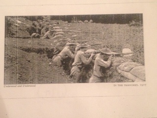
In the years prior to World War I, a boathouse was built on Bantam Lake.  Future expansion was halted by the coming of war, and in 1917, officers’ training for the United States Army took place on the property.  Trenches were dug near Munger Lane, and mock infantry assaults swept the camp.  In 1918, the university issued an informational packet for those interested in a second round of training at the camp, which stated that the purpose was to offer “an officers’ training course for men who may be called to the National Army and desire to fit themselves for officers of noncommissioned officers in Government Service.”  The packet stated that the program was conducted by the university, not the Army, but that  it had “the approval and endorsement of the Secretary of War, and the record of the men who attended last summer shows that the course has been effective in preparing men for officers’ rank, real usefulness, and rapid advancement.”

tower

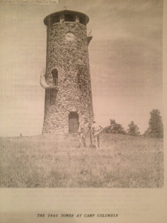
A 1940s image of the Camp Columbia tower; the tower is still standing but no longer has the hands on the clock. Photo courtesy of Columbia University.

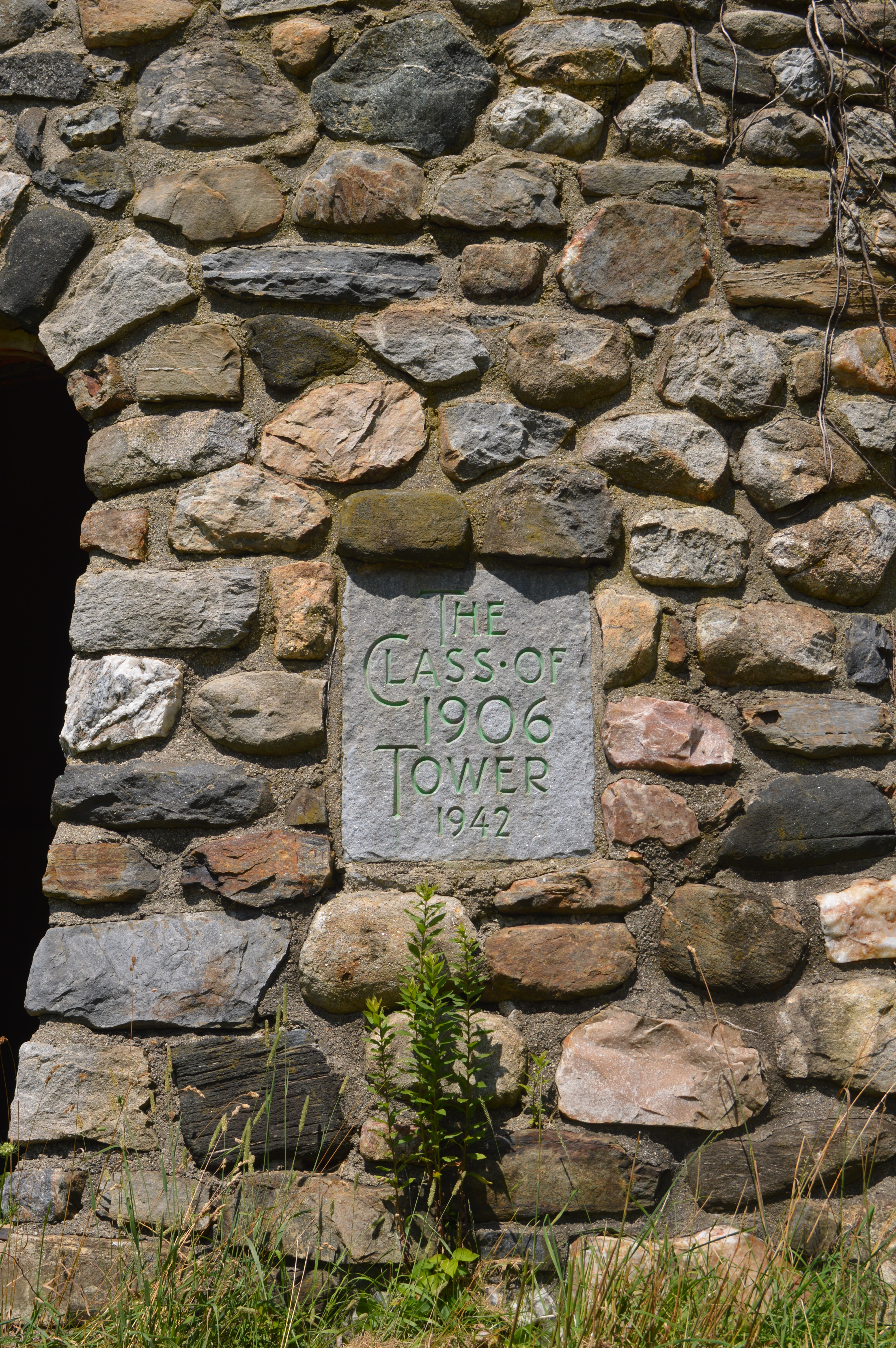
In 1934, a fieldstone dining hall was built and eight years later the central feature of the camp, a 60 foot cylindrical water tower with an observation platform made of local stone was presented to the camp by the Class of 1906.  A 1952 Columbia University press release describes the tower as a “land-locked lighthouse, or the battlement of a feudal castle.”

columbia-university-dwight-eisenhower-1948

Dwight Eisenhower as president of Columbia University.

 Columbia engineering students blasted and leveled the hilly terrain to create a softball field and football field.  In the late 1940s, the Columbia Lions football team held their early season practices here under Coach Lou Little, who paced the sidelines at the school for 26 seasons and was inducted into the College Football Hall of Fame in 1960.  Little was supported in his efforts by the then president of Columbia, Dwight D. Eisenhower.  Ike is reported to have spent time at the camp watching practices and hunting on the grounds.

DSC_0192

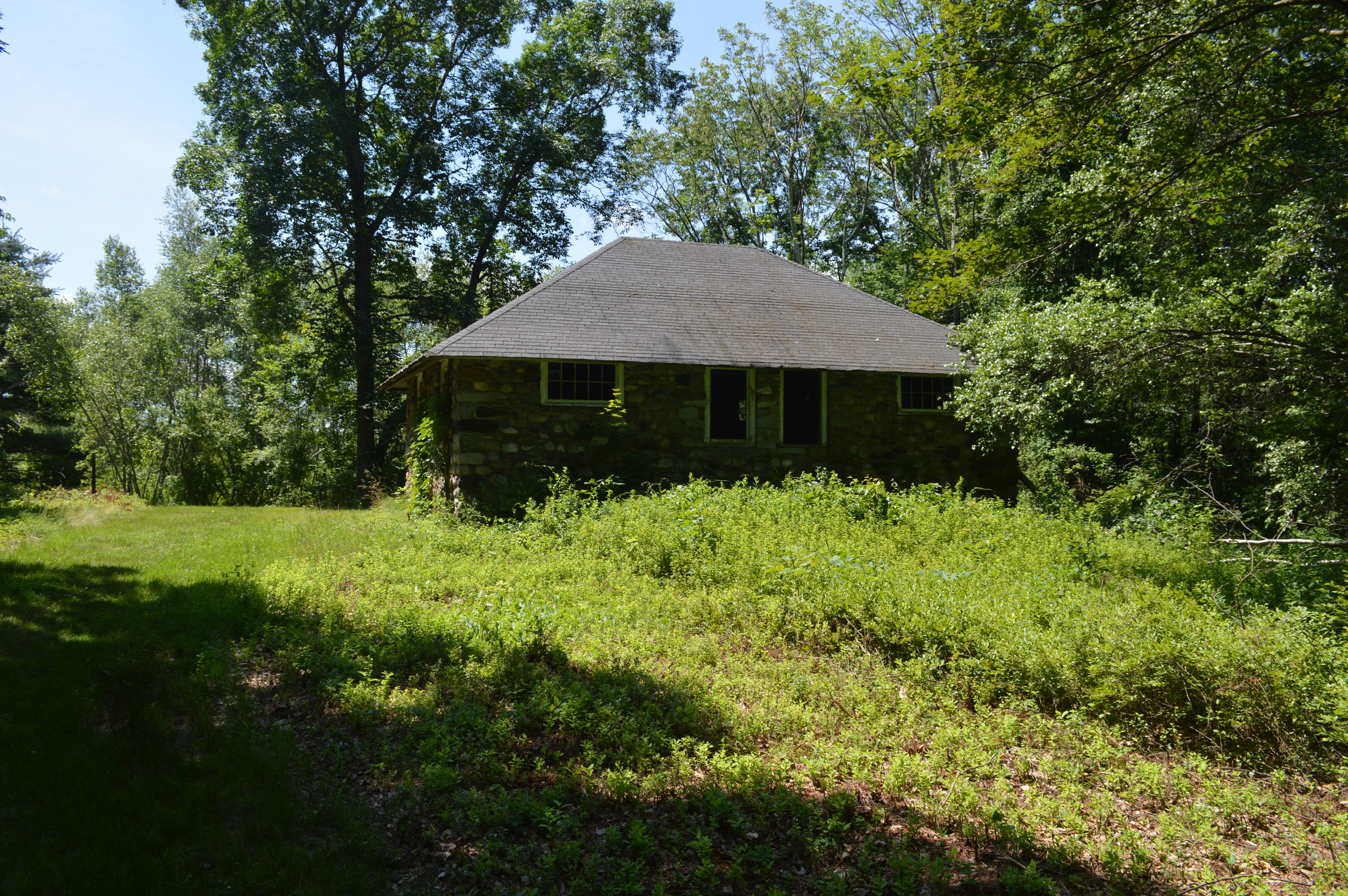
The Instrument House, one of two surviving structures.

Still, the primary purpose of the camp was as a field school for engineering students, and by the early 1950s the summer program was mandatory for these students.  Courses taught at the camp included Chemical Engineering, Civil Engineering, and Technology & International Affairs.  Additionally, the Columbia University American Language Center offered classes for those international students who wished to apply to American colleges.  The presence of the 60 or so international students in 1952 – from Korea, China, Japan, Malaya, Norway, Sweden, Colombia, Greece, Canada, Brazil, Engalnd and Italy – allowed the university to declare that the camp was “a veritable United Nations in microscosm, the youngsters live together and work together with no more friction than one would find in any other college class.”

Remains of the old flag circle at Camp Columbia.

Remains of the old flag circle at Camp Columbia.

By the mid-1960s, declining student interest in the camp experience and changes to the engineering curriculum brought an end to the Engineering Department’s use of Camp Columbia.  The university maintained the grounds for special programming until 1983 when it was closed.  While the university struggled to find a buyer for the property, the buildings slowly deteriorated.  In 1989, the Town of Morris declared several buildings to be a public hazard and they were utilized in a controlled burning training exercise.

DSC_0196

Remains of an old fountain at Camp Columbia.

In 2000, the State of Connecticut agreed to purchase the grounds for $2.1 million and began to remove most of the buildings.  Today, only the boathouse, tower and instrument house still stand.  Still, for the explorer willing to walk the grounds, hints of foundations and clearings in the forest provide a glimpse into what was once a thriving intellectual community.

The Original Site of St. Michael’s Church

2013-08-06 11.34.16

This small, difficult to find marker stands along Route 202 between the ABC Music Shop and the Tapping Reeve Condominiums.  It marks the first location of St. Michael’s Episcopal Church.

peppercorn_black

Peppercorns

The church was founded in November 1745 at a meeting of the heads of thirteen Litchfield families.  While the numbers of Episcopalians in colonial Connecticut paled in comparison to the number of Congregationalists, Litchfield’s families were fortunate to have a strong leader in John Davies.  Davies, who had been born in England, donated money to build the church and leased the land on which the first church stood.  The terms of the lease between Davies and the Society of the Propagation of the Gospel in Foreign Parts called for the parish to pay Davies one peppercorn annually on the feast of St. Michael the Archangel.  Thus, the parish got its name.

GeorgeWashington

The Revolutionary War was a particularly trying time for the church, as parishioners took an oath of loyalty to both the King of England and the Archbishop of Canterbury.  The church closed completely between 1777 and 1780, and American soldiers allegedly threw stones at the structure as they passed through Litchfield until they were stopped by George Washington, himself an Episcopalian.  Approximately 20% of Connecticut’s Episcopalians fled to Canada as a result of the war.

In 1784, the Connecticut General Assembly officially recognized the Episcopal Church and the Episcopal Society of Litchfield was organized.  Further stability came the following year when Rev. Ashbel Baldwin was installed at the pulpit in Litchfield.

St.Mich.Litchfield

St. Michael’s Church today

These developments, coupled with the cessation of Episcopalian loyalty to the King, led to the need for a larger church. This resulted in the parish’s move to South Street, the site where the current church built between 1918 and 1920 still stands.