The Prospect Street bridge over the Naugatuck River in Torrington (Connecticuthistory.org)
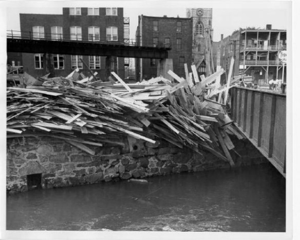
The Flood of 1955, the worst natural disaster in Connecticut history, resulted from the approximately two feet of rain dropped by Hurricanes Connie and Diane that August. Low-lying areas were already flooded on the morning of August 18th when the second storm dumped fourteen more inches that afternoon and on August 19th. The Housatonic stood at 24.5 feet deep and the Mad and Still Rivers in Winsted raged at 50 miles per hour. In Torrington, the Naugatuck River, so peaceful looking today, swept away lumber, rocks, even buildings. Stores along East Main Street were filled with six feet of water. The city suffered an estimated $22 million dollars in damage.
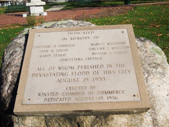
Memorial to flood victims in Winsted
A similar scene played out in Winsted, while the Shepaug River carried away an apartment building in Washington Depot. Concrete sections of Route 44 were washed away and across the county, Bailey bridges – made famous during World War II – were used to provide temporary river crossings. Twenty-five helicopters searched for survivors or dropped clean food and water. Statewide, 87 people were killed, and over 8,000 buildings were damaged or destroyed. Twenty five of the dead were from Litchfield County. Memorials stand in Torrington and Winsted to those who lost their lives.

American Brass factory, Torrington
Extraordinary acts of heroism by police, firemen, and ordinary citizens kept the death toll from growing. In its August 26th, 1955 edition the Torrington Register proclaimed, “So numerous were the many acts of heroism, rescue of the sick and invalid, neighbors’ concern for neighbors, that it would impossible to chronicle them without slighting someone deserving of great credit.

Thomaston Dam
In addition to severely (in some places irreparably) damaging the state’s industrial infrastructure, the floods forced the Army Corps of Engineers to take action so that such a disaster never happened again. The army constructed the Thomaston Dam (1960), Northfield Brook Dam (1965), and Colebrook Dam (1969), at a cost of $70 million. The Naugatuck River, with its many tributaries, had been especially prone to flooding and the dams constructed along that river provided over 77,000 acres of flood capacity, while returning over 1,000 acres to forest. This protection came at a price as construction displaced the communities of Fluteville and Campville in Litchfield. Still, it is perhaps fortunate that the traveler through Torrington today has difficulty in imagining the destructive power of the now-controlled Naugatuck River.
Please see “The Lost,” a special section of the Hartford Courant for tributes to those who died in the Flood of 1955: http://www.courant.com/news/connecticut/hc-55flood-casualties-htmlstory.html
Also see the Torrington Register-Citizen’s photo archive of the flood: https://picasaweb.google.com/lh/albumMap?uname=kaitlynmyeager&aid=5547678124797887025#map


